Tengger geodata
Tengger (Central Java) is a seat of a fourth-order administrative division; located in Indonesia in Asia/Jakarta (GMT+7) time zone. In our database, there are 407 cities with bigger population. Compared to other cities in Indonesia, 75.2% of cities are located further ↓South; 57.1% of cities are located further →East and 60.4% of cities have lower elevation than Tengger. Note1


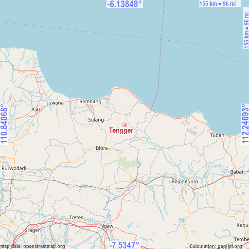
Tengger GPS coordinates[2]
6° 50' 13.56" South, 111° 32' 37.68" East
| Map corner | latitude | longitude |
|---|---|---|
| Upper-left | -6.13848°, | 110.84068° |
| Center: | -6.8371°, | 111.5438° |
| Lower-right: | -7.5347°, | 112.24693° |
| Map W x H: | 155.2×155.2 km | = 96.4×96.4mi |
| max Lat: | 5.88969° ⇑24.8% North |
| Tengger: | -6.8371° |
| min Lat: | ⇓75.2% South -10.934° |
| min Long | Tengger | max Long |
| 95.1345° | 111.5438° | 140.9419° |
| W 42.9%⇐ | ⇒57.1% E |
Elevation
Elevation of Tengger is 168 m = 551 ft, and this is 61.7 m = 202 ft below average elevation for this country.
| Max E: |
3185 m = 10449 ft | 39.6% |
| Avg. | 229.7 m = 754 ft | |
| Tengger | 168 m = 551 ft | |
Min E: |
-1 m = -3 ft | 60.4% |
See also: Indonesia elevation on elevation.city.
Geographical zone
Tengger is located in South Torrid zone (between Equator and Tropic of Capricorn). Distance of Equator is 760.2 km =472.4 mi to North.| Distance of | km | miles | from Tengger |
|---|---|---|---|
| Equator | 760.2 | 472.4 | to North |
| Tropic Capricorn | 1845.7 | 1146.9 | to South |
| Antarctic Circle | 6641 | 4126.5 | to South |
| South Pole | 9246.8 | 5745.7 | to South |


Nearby cities:
15 places around Tengger: (largest is in red/bold)
• Bamban
5.5 km =3.4 mi,  330°
330°
• Dowan
4.4 km =2.7 mi,  266°
266°
• Gading Barat
5.1 km =3.2 mi,  159°
159°
• Jatirego
2.6 km =1.6 mi,  262°
262°
• Jinanten
5.4 km =3.4 mi,  143°
143°
• Joho
5.7 km =3.5 mi,  124°
124°
• Mrayun
6.5 km =4 mi,  131°
131°
• Ngandang
2.7 km =1.7 mi,  29°
29°
• Pakis
4.1 km =2.5 mi,  290°
290°
• Rendeng
4.5 km =2.8 mi,  312°
312°
• Suntri
4.1 km =2.5 mi,  253°
253°
• Tahunan
5.4 km =3.4 mi,  169°
169°
• Tegaldowo
5 km =3.1 mi,  244°
244°
• Ukir
5.1 km =3.2 mi,  315°
315°
• Wonokerto
4.8 km =3 mi,  110°
110°
Sources, notices
• [Note1] Compared only with cities in Indonesia existing in our database
• [Src1] Map data: © OpenStreetMap contributors (CC-BY-SA)
• [Src2] Other city data from geonames.org with taken over terms of usage.
• [Src3] Geographical zone / Annual Mean Temperature by Robert A. Rohde @ Wikipedia
