Tahunan geodata
Tahunan (Central Java) is a seat of a fourth-order administrative division; located in Indonesia in Asia/Jakarta (GMT+7) time zone. In our database, there are 407 cities with bigger population. Compared to other cities in Indonesia, 73.7% of cities are located further ↓South; 57% of cities are located further →East and 57.9% of cities have lower elevation than Tahunan. Note1


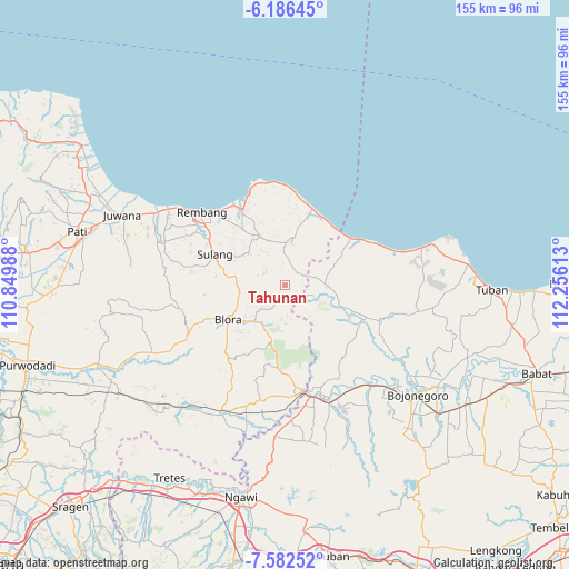
Tahunan GPS coordinates[2]
6° 53' 6" South, 111° 33' 10.8" East
| Map corner | latitude | longitude |
|---|---|---|
| Upper-left | -6.18645°, | 110.84988° |
| Center: | -6.885°, | 111.553° |
| Lower-right: | -7.58252°, | 112.25613° |
| Map W x H: | 155.2×155.2 km | = 96.4×96.4mi |
| max Lat: | 5.88969° ⇑26.3% North |
| Tahunan: | -6.885° |
| min Lat: | ⇓73.7% South -10.934° |
| min Long | Tahunan | max Long |
| 95.1345° | 111.553° | 140.9419° |
| W 43%⇐ | ⇒57% E |
Elevation
Elevation of Tahunan is 145 m = 476 ft, and this is 84.7 m = 278 ft below average elevation for this country.
| Max E: |
3185 m = 10449 ft | 42.1% |
| Avg. | 229.7 m = 754 ft | |
| Tahunan | 145 m = 476 ft | |
Min E: |
-1 m = -3 ft | 57.9% |
See also: Indonesia elevation on elevation.city.
Geographical zone
Tahunan is located in South Torrid zone (between Equator and Tropic of Capricorn). Distance of Equator is 765.5 km =475.7 mi to North.| Distance of | km | miles | from Tahunan |
|---|---|---|---|
| Equator | 765.5 | 475.7 | to North |
| Tropic Capricorn | 1840.4 | 1143.6 | to South |
| Antarctic Circle | 6635.6 | 4123.2 | to South |
| South Pole | 9241.5 | 5742.4 | to South |


Nearby cities:
15 places around Tahunan: (largest is in red/bold)
• Bancang
5.1 km =3.2 mi,  90°
90°
• Blimbing
3.5 km =2.2 mi,  213°
213°
• Gading Barat
0.9 km =0.6 mi,  55°
55°
• Gayamdesa
4.7 km =2.9 mi,  195°
195°
• Jinanten
2.4 km =1.5 mi, 64°
• Jlodro
5.8 km =3.6 mi,  144°
144°
• Joho
4.2 km =2.6 mi, 60°
• Kaliprak
3.3 km =2.1 mi, 92°
• Mrayun
4 km =2.5 mi,  75°
75°
• Nglengkir
6 km =3.7 mi,  229°
229°
• Sale
6.2 km =3.9 mi,  65°
65°
• Sendangrejo
3.9 km =2.4 mi,  169°
169°
• Tengger
5.4 km =3.4 mi,  349°
349°
• Wanutengah
5.1 km =3.2 mi, 210°
• Wonokerto
5 km =3.1 mi,  44°
44°
Sources, notices
• [Note1] Compared only with cities in Indonesia existing in our database
• [Src1] Map data: © OpenStreetMap contributors (CC-BY-SA)
• [Src2] Other city data from geonames.org with taken over terms of usage.
• [Src3] Geographical zone / Annual Mean Temperature by Robert A. Rohde @ Wikipedia
