Jurangjero geodata
Jurangjero (Central Java) is a seat of a fourth-order administrative division; located in Indonesia in Asia/Jakarta (GMT+7) time zone. In our database, there are 407 cities with bigger population. Compared to other cities in Indonesia, 72.3% of cities are located further ↓South; 57.8% of cities are located further →East and 68.2% of cities have lower elevation than Jurangjero. Note1


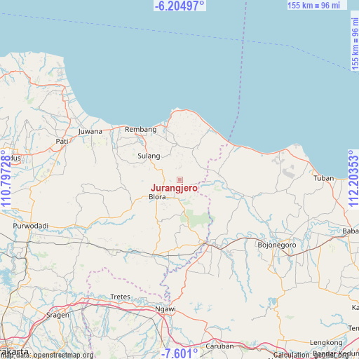
Jurangjero GPS coordinates[2]
6° 54' 12.6" South, 111° 30' 1.44" East
| Map corner | latitude | longitude |
|---|---|---|
| Upper-left | -6.20497°, | 110.79728° |
| Center: | -6.9035°, | 111.5004° |
| Lower-right: | -7.601°, | 112.20353° |
| Map W x H: | 155.2×155.2 km | = 96.4×96.4mi |
| max Lat: | 5.88969° ⇑27.7% North |
| Jurangjero: | -6.9035° |
| min Lat: | ⇓72.3% South -10.934° |
| min Long | Jurangjero | max Long |
| 95.1345° | 111.5004° | 140.9419° |
| W 42.2%⇐ | ⇒57.8% E |
Elevation
Elevation of Jurangjero is 266 m = 873 ft, and this is 36.3 m = 119 ft above average elevation for this country.
| Max E: |
3185 m = 10449 ft | 31.8% |
| Jurangjero | 266 m 873 ft | |
| Avg. | 229.7 m = 754 ft | |
Min E: |
-1 m = -3 ft | 68.2% |
See also: Indonesia elevation on elevation.city.
Geographical zone
Jurangjero is located in South Torrid zone (between Equator and Tropic of Capricorn). Distance of Equator is 767.6 km =477 mi to North.| Distance of | km | miles | from Jurangjero |
|---|---|---|---|
| Equator | 767.6 | 477 | to North |
| Tropic Capricorn | 1838.3 | 1142.3 | to South |
| Antarctic Circle | 6633.6 | 4121.9 | to South |
| South Pole | 9239.5 | 5741.2 | to South |


Nearby cities:
15 places around Jurangjero: (largest is in red/bold)
• Bacem
4.3 km =2.7 mi,  232°
232°
• Blimbing
4 km =2.5 mi,  103°
103°
• Gombang
4.4 km =2.7 mi,  201°
201°
• Jatirejo
3.7 km =2.3 mi,  239°
239°
• Jeruk
4 km =2.5 mi,  169°
169°
• Kajar
3.2 km =2 mi,  317°
317°
• Karang
3.9 km =2.4 mi,  185°
185°
• Karanganyar
3.1 km =1.9 mi,  205°
205°
• Karangasem
1.5 km =0.9 mi,  287°
287°
• Kemiren
3.6 km =2.2 mi,  278°
278°
• Nglengkir
2.2 km =1.4 mi,  146°
146°
• Sarirejo
3.9 km =2.4 mi, 213°
• Tempuran
4.4 km =2.7 mi,  258°
258°
• Wanutengah
4 km =2.5 mi,  126°
126°
• Waru
1.8 km =1.1 mi,  330°
330°
Sources, notices
• [Note1] Compared only with cities in Indonesia existing in our database
• [Src1] Map data: © OpenStreetMap contributors (CC-BY-SA)
• [Src2] Other city data from geonames.org with taken over terms of usage.
• [Src3] Geographical zone / Annual Mean Temperature by Robert A. Rohde @ Wikipedia
