Karanganyar geodata
Karanganyar (Central Java) is a seat of a fourth-order administrative division; located in Indonesia in Asia/Jakarta (GMT+7) time zone. In our database, there are 407 cities with bigger population. Compared to other cities in Indonesia, 70.7% of cities are located further ↓South; 58.1% of cities are located further →East and 53.7% of cities have lower elevation than Karanganyar. Note1


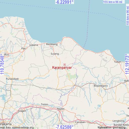
Karanganyar GPS coordinates[2]
6° 55' 42.24" South, 111° 29' 18.96" East
| Map corner | latitude | longitude |
|---|---|---|
| Upper-left | -6.22991°, | 110.78548° |
| Center: | -6.9284°, | 111.4886° |
| Lower-right: | -7.62586°, | 112.19173° |
| Map W x H: | 155.2×155.2 km | = 96.4×96.4mi |
| max Lat: | 5.88969° ⇑29.3% North |
| Karanganyar: | -6.9284° |
| min Lat: | ⇓70.7% South -10.934° |
| min Long | Karanganyar | max Long |
| 95.1345° | 111.4886° | 140.9419° |
| W 41.9%⇐ | ⇒58.1% E |
Elevation
Elevation of Karanganyar is 118 m = 387 ft, and this is 111.7 m = 366 ft below average elevation for this country.
| Max E: |
3185 m = 10449 ft | 46.3% |
| Avg. | 229.7 m = 754 ft | |
| Karanganyar | 118 m = 387 ft | |
Min E: |
-1 m = -3 ft | 53.7% |
See also: Indonesia elevation on elevation.city.
Geographical zone
Karanganyar is located in South Torrid zone (between Equator and Tropic of Capricorn). Distance of Equator is 770.4 km =478.7 mi to North.| Distance of | km | miles | from Karanganyar |
|---|---|---|---|
| Equator | 770.4 | 478.7 | to North |
| Tropic Capricorn | 1835.6 | 1140.6 | to South |
| Antarctic Circle | 6630.8 | 4120.2 | to South |
| South Pole | 9236.7 | 5739.4 | to South |


Nearby cities:
15 places around Karanganyar: (largest is in red/bold)
• Bacem
2.1 km =1.3 mi,  273°
273°
• Bogorejo
3.6 km =2.2 mi,  111°
111°
• Gombang
1.4 km =0.9 mi,  192°
192°
• Jatirejo
2.1 km =1.3 mi,  295°
295°
• Jeruk
2.3 km =1.4 mi,  119°
119°
• Jurangjero
3.1 km =1.9 mi,  25°
25°
• Karang
1.4 km =0.9 mi,  139°
139°
• Karangasem
3.2 km =2 mi,  357°
357°
• Kawengan
2.1 km =1.3 mi,  237°
237°
• Nglarohgunung
4 km =2.5 mi, 190°
• Nglengkir
2.7 km =1.7 mi,  69°
69°
• Prantaan
2.2 km =1.4 mi,  152°
152°
• Puledagel
3.3 km =2.1 mi,  258°
258°
• Sarirejo
1 km =0.6 mi, 240°
• Tempuran
3.6 km =2.2 mi, 301°
Sources, notices
• [Note1] Compared only with cities in Indonesia existing in our database
• [Src1] Map data: © OpenStreetMap contributors (CC-BY-SA)
• [Src2] Other city data from geonames.org with taken over terms of usage.
• [Src3] Geographical zone / Annual Mean Temperature by Robert A. Rohde @ Wikipedia
