Rungkang geodata
Rungkang (Central Java) is a seat of a fourth-order administrative division; located in Indonesia in Asia/Jakarta (GMT+7) time zone. In our database, there are 407 cities with bigger population. Compared to other cities in Indonesia, 54.2% of cities are located further ↑North; 67.3% of cities are located further →East and 63.8% of cities have lower elevation than Rungkang. Note1


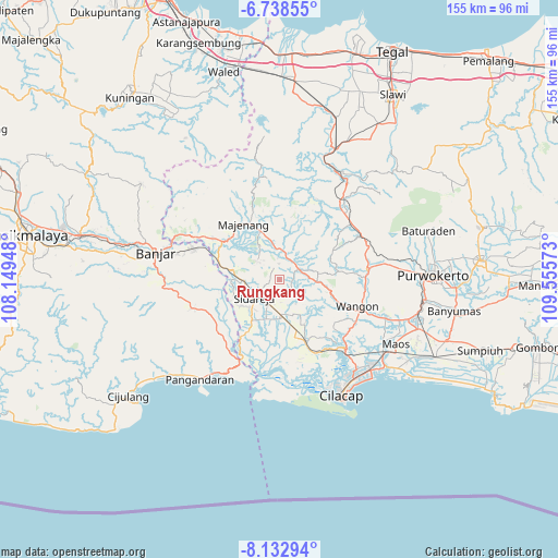
Rungkang GPS coordinates[2]
7° 26' 10.68" South, 108° 51' 9.36" East
| Map corner | latitude | longitude |
|---|---|---|
| Upper-left | -6.73855°, | 108.14948° |
| Center: | -7.4363°, | 108.8526° |
| Lower-right: | -8.13294°, | 109.55573° |
| Map W x H: | 155×155 km | = 96.3×96.3mi |
| max Lat: | 5.88969° ⇑54.2% North |
| Rungkang: | -7.4363° |
| min Lat: | ⇓45.8% South -10.934° |
| min Long | Rungkang | max Long |
| 95.1345° | 108.8526° | 140.9419° |
| W 32.7%⇐ | ⇒67.3% E |
Elevation
Elevation of Rungkang is 205 m = 673 ft, and this is 24.7 m = 81 ft below average elevation for this country.
| Max E: |
3185 m = 10449 ft | 36.2% |
| Avg. | 229.7 m = 754 ft | |
| Rungkang | 205 m = 673 ft | |
Min E: |
-1 m = -3 ft | 63.8% |
See also: Indonesia elevation on elevation.city.
Geographical zone
Rungkang is located in South Torrid zone (between Equator and Tropic of Capricorn). Distance of Equator is 826.8 km =513.7 mi to North.| Distance of | km | miles | from Rungkang |
|---|---|---|---|
| Equator | 826.8 | 513.7 | to North |
| Tropic Capricorn | 1779.1 | 1105.5 | to South |
| Antarctic Circle | 6574.3 | 4085.1 | to South |
| South Pole | 9180.2 | 5704.3 | to South |


Nearby cities:
15 places around Rungkang: (largest is in red/bold)
• Cidadap
4.3 km =2.7 mi,  359°
359°
• Cikondang
6.4 km =4 mi,  229°
229°
• Ciloning
4.3 km =2.7 mi,  181°
181°
• Dukuhsawah
7.8 km =4.8 mi,  265°
265°
• Gendiwu
7.5 km =4.7 mi,  217°
217°
• Genteng Wetan
7.8 km =4.8 mi,  10°
10°
• Gunungwilis
5.8 km =3.6 mi,  288°
288°
• Karanggintung
2.5 km =1.6 mi,  163°
163°
• Karangsalam
2.9 km =1.8 mi,  255°
255°
• Pangawaren
5.7 km =3.5 mi,  19°
19°
• Pasanggrahan
6.2 km =3.9 mi, 19°
• Sidamulya
7.8 km =4.8 mi, 222°
• Tambangan
6.5 km =4 mi,  211°
211°
• Tawangsari
6.9 km =4.3 mi,  310°
310°
• Wonodadi
3.2 km =2 mi, 222°
Sources, notices
• [Note1] Compared only with cities in Indonesia existing in our database
• [Src1] Map data: © OpenStreetMap contributors (CC-BY-SA)
• [Src2] Other city data from geonames.org with taken over terms of usage.
• [Src3] Geographical zone / Annual Mean Temperature by Robert A. Rohde @ Wikipedia
