Wonodadi geodata
Wonodadi (Central Java) is a seat of a fourth-order administrative division; located in Indonesia in Asia/Jakarta (GMT+7) time zone. In our database, there are 407 cities with bigger population. Compared to other cities in Indonesia, 54.8% of cities are located further ↑North; 67.4% of cities are located further →East and 60.7% of cities have lower elevation than Wonodadi. Note1


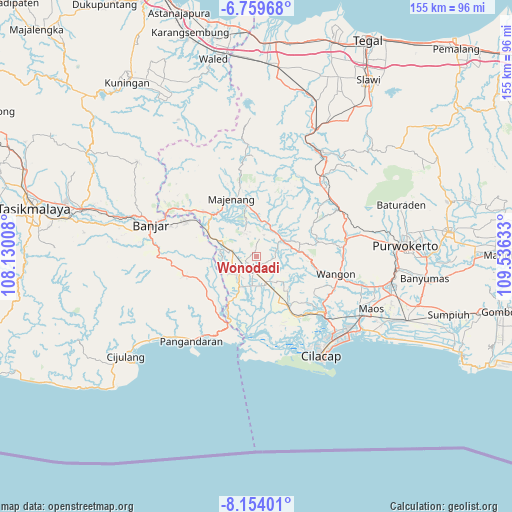
Wonodadi GPS coordinates[2]
7° 27' 26.64" South, 108° 49' 59.52" East
| Map corner | latitude | longitude |
|---|---|---|
| Upper-left | -6.75968°, | 108.13008° |
| Center: | -7.4574°, | 108.8332° |
| Lower-right: | -8.15401°, | 109.53633° |
| Map W x H: | 155×155 km | = 96.3×96.3mi |
| max Lat: | 5.88969° ⇑54.8% North |
| Wonodadi: | -7.4574° |
| min Lat: | ⇓45.2% South -10.934° |
| min Long | Wonodadi | max Long |
| 95.1345° | 108.8332° | 140.9419° |
| W 32.6%⇐ | ⇒67.4% E |
Elevation
Elevation of Wonodadi is 172 m = 564 ft, and this is 57.7 m = 189 ft below average elevation for this country.
| Max E: |
3185 m = 10449 ft | 39.3% |
| Avg. | 229.7 m = 754 ft | |
| Wonodadi | 172 m = 564 ft | |
Min E: |
-1 m = -3 ft | 60.7% |
See also: Indonesia elevation on elevation.city.
Geographical zone
Wonodadi is located in South Torrid zone (between Equator and Tropic of Capricorn). Distance of Equator is 829.2 km =515.2 mi to North.| Distance of | km | miles | from Wonodadi |
|---|---|---|---|
| Equator | 829.2 | 515.2 | to North |
| Tropic Capricorn | 1776.7 | 1104 | to South |
| Antarctic Circle | 6572 | 4083.7 | to South |
| South Pole | 9177.9 | 5702.9 | to South |


Nearby cities:
15 places around Wonodadi: (largest is in red/bold)
• Alurbulu
6.1 km =3.8 mi,  172°
172°
• Cikalong
5.2 km =3.2 mi,  239°
239°
• Ciklapa
6.5 km =4 mi,  205°
205°
• Cikondang
3.2 km =2 mi, 236°
• Ciloning
2.8 km =1.7 mi,  133°
133°
• Dukuhsawah
5.9 km =3.7 mi,  287°
287°
• Gendiwu
4.3 km =2.7 mi, 213°
• Gunungwilis
5.3 km =3.3 mi,  321°
321°
• Karanggintung
2.8 km =1.7 mi,  91°
91°
• Karangsalam
1.7 km =1.1 mi,  338°
338°
• Kauman
5.7 km =3.5 mi, 243°
• Rungkang
3.2 km =2 mi,  42°
42°
• Sidamulya
4.7 km =2.9 mi,  222°
222°
• Sidareja
5.4 km =3.4 mi, 236°
• Tambangan
3.4 km =2.1 mi,  201°
201°
Sources, notices
• [Note1] Compared only with cities in Indonesia existing in our database
• [Src1] Map data: © OpenStreetMap contributors (CC-BY-SA)
• [Src2] Other city data from geonames.org with taken over terms of usage.
• [Src3] Geographical zone / Annual Mean Temperature by Robert A. Rohde @ Wikipedia
