Karangharjo geodata
Karangharjo (Central Java) is a seat of a fourth-order administrative division; located in Indonesia in Asia/Jakarta (GMT+7) time zone. In our database, there are 407 cities with bigger population. Compared to other cities in Indonesia, 80.8% of cities are located further ↓South; 55.8% of cities are located further →East and 95.5% of cities have higher elevation than Karangharjo. Note1


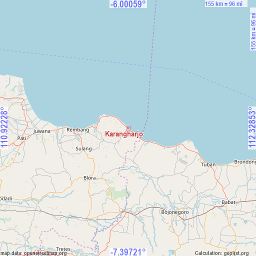
Karangharjo GPS coordinates[2]
6° 41' 57.84" South, 111° 37' 31.44" East
| Map corner | latitude | longitude |
|---|---|---|
| Upper-left | -6.00059°, | 110.92228° |
| Center: | -6.6994°, | 111.6254° |
| Lower-right: | -7.39721°, | 112.32853° |
| Map W x H: | 155.3×155.3 km | = 96.5×96.5mi |
| max Lat: | 5.88969° ⇑19.2% North |
| Karangharjo: | -6.6994° |
| min Lat: | ⇓80.8% South -10.934° |
| min Long | Karangharjo | max Long |
| 95.1345° | 111.6254° | 140.9419° |
| W 44.2%⇐ | ⇒55.8% E |
Elevation
Elevation of Karangharjo is 7 m = 23 ft, and this is 222.7 m = 731 ft below average elevation for this country.
| Max E: |
3185 m = 10449 ft | 95.5% |
| Avg. | 229.7 m = 754 ft | |
| Karangharjo | 7 m = 23 ft | |
Min E: |
-1 m = -3 ft | 4.5% |
See also: Indonesia elevation on elevation.city.
Geographical zone
Karangharjo is located in South Torrid zone (between Equator and Tropic of Capricorn). Distance of Equator is 744.9 km =462.9 mi to North.| Distance of | km | miles | from Karangharjo |
|---|---|---|---|
| Equator | 744.9 | 462.9 | to North |
| Tropic Capricorn | 1861 | 1156.4 | to South |
| Antarctic Circle | 6656.3 | 4136 | to South |
| South Pole | 9262.2 | 5755.3 | to South |


Nearby cities:
15 places around Karangharjo: (largest is in red/bold)
• Balongmulyo
3.4 km =2.1 mi,  308°
308°
• Gonggang
4.1 km =2.5 mi,  172°
172°
• Kalipang
4.2 km =2.6 mi,  131°
131°
• Karanganyar
0.8 km =0.5 mi, 129°
• Karanglincak
0.4 km =0.2 mi, 125°
• Kebloran
1.3 km =0.8 mi, 127°
• Kendalagung
2.6 km =1.6 mi,  245°
245°
• Kragan
1.8 km =1.1 mi, 307°
• Menara
4.9 km =3 mi,  229°
229°
• Mojokerto
4.2 km =2.6 mi,  205°
205°
• Narukan
4.8 km =3 mi,  276°
276°
• Ngasinan
4.6 km =2.9 mi, 248°
• Ngilengan
2.7 km =1.7 mi,  162°
162°
• Plawangan
4.4 km =2.7 mi, 309°
• Tanjungan
1.5 km =0.9 mi, 130°
Sources, notices
• [Note1] Compared only with cities in Indonesia existing in our database
• [Src1] Map data: © OpenStreetMap contributors (CC-BY-SA)
• [Src2] Other city data from geonames.org with taken over terms of usage.
• [Src3] Geographical zone / Annual Mean Temperature by Robert A. Rohde @ Wikipedia
