Kebonsari geodata
Kebonsari (East Java) is a seat of a fourth-order administrative division; located in Indonesia in Asia/Jakarta (GMT+7) time zone. In our database, there are 407 cities with bigger population. Compared to other cities in Indonesia, 72.3% of cities are located further ↓South; 50.6% of cities are located further ←West and 81.9% of cities have higher elevation than Kebonsari. Note1


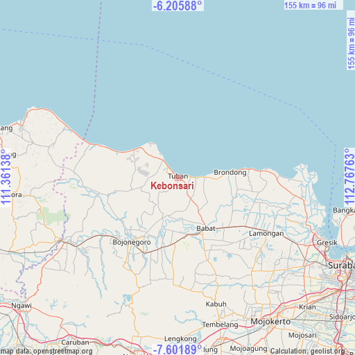
Kebonsari GPS coordinates[2]
6° 54' 15.84" South, 112° 3' 52.2" East
| Map corner | latitude | longitude |
|---|---|---|
| Upper-left | -6.20588°, | 111.36138° |
| Center: | -6.9044°, | 112.0645° |
| Lower-right: | -7.60189°, | 112.76763° |
| Map W x H: | 155.2×155.2 km | = 96.4×96.4mi |
| max Lat: | 5.88969° ⇑27.7% North |
| Kebonsari: | -6.9044° |
| min Lat: | ⇓72.3% South -10.934° |
| min Long | Kebonsari | max Long |
| 95.1345° | 112.0645° | 140.9419° |
| W 50.6%⇐ | ⇒49.4% E |
Elevation
Elevation of Kebonsari is 17 m = 56 ft, and this is 212.7 m = 698 ft below average elevation for this country.
| Max E: |
3185 m = 10449 ft | 81.9% |
| Avg. | 229.7 m = 754 ft | |
| Kebonsari | 17 m = 56 ft | |
Min E: |
-1 m = -3 ft | 18.1% |
See also: Indonesia elevation on elevation.city.
Geographical zone
Kebonsari is located in South Torrid zone (between Equator and Tropic of Capricorn). Distance of Equator is 767.7 km =477 mi to North.| Distance of | km | miles | from Kebonsari |
|---|---|---|---|
| Equator | 767.7 | 477 | to North |
| Tropic Capricorn | 1838.2 | 1142.2 | to South |
| Antarctic Circle | 6633.5 | 4121.9 | to South |
| South Pole | 9239.4 | 5741.1 | to South |


Nearby cities:
15 places around Kebonsari: (largest is in red/bold)
• Bejagung Kidul
1.8 km =1.1 mi,  183°
183°
• Gedongombo
0.6 km =0.4 mi, 177°
• Kajongan
1.3 km =0.8 mi,  339°
339°
• Karang
1.1 km =0.7 mi,  244°
244°
• Krajan Bejagung
1.3 km =0.8 mi, 183°
• Kranggan
1.7 km =1.1 mi,  311°
311°
• Kuncen
1 km =0.6 mi,  45°
45°
• Kutorejo
1.1 km =0.7 mi,  351°
351°
• Merik
1.7 km =1.1 mi,  278°
278°
• Paloh
2 km =1.2 mi,  325°
325°
• Sendangharjo
1.2 km =0.7 mi,  20°
20°
• Sidomukti
0.7 km =0.4 mi,  285°
285°
• Sukolilo
1.7 km =1.1 mi,  56°
56°
• Tegalagung
1.9 km =1.2 mi, 236°
• Tuban
0.8 km =0.5 mi,  3°
3°
Sources, notices
• [Note1] Compared only with cities in Indonesia existing in our database
• [Src1] Map data: © OpenStreetMap contributors (CC-BY-SA)
• [Src2] Other city data from geonames.org with taken over terms of usage.
• [Src3] Geographical zone / Annual Mean Temperature by Robert A. Rohde @ Wikipedia
