Tuban geodata
Tuban (East Java) is a seat of a second-order administrative division; located in Indonesia in Asia/Jakarta (GMT+7) time zone. With population of 76,242 people, there are 167 cities with bigger population in this country. Compared to other cities in Indonesia, 72.8% of cities are located further ↓South; 50.7% of cities are located further ←West and 86.4% of cities have higher elevation than Tuban. Note1


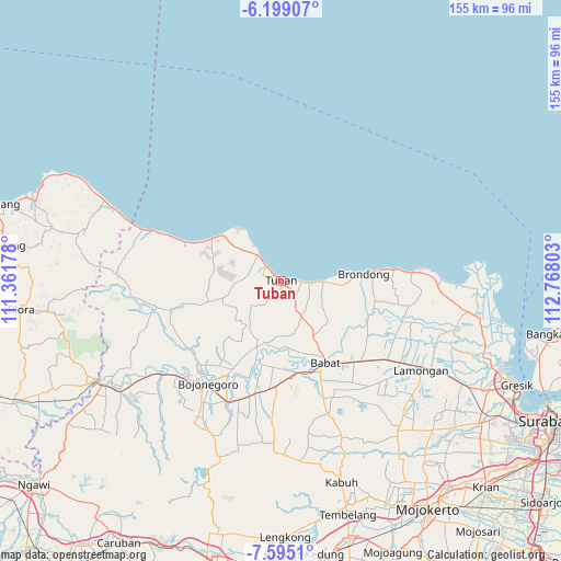
Tuban GPS coordinates[2]
6° 53' 51.36" South, 112° 3' 53.64" East
| Map corner | latitude | longitude |
|---|---|---|
| Upper-left | -6.19907°, | 111.36178° |
| Center: | -6.8976°, | 112.0649° |
| Lower-right: | -7.5951°, | 112.76803° |
| Map W x H: | 155.2×155.2 km | = 96.4×96.4mi |
| max Lat: | 5.88969° ⇑27.2% North |
| Tuban: | -6.8976° |
| min Lat: | ⇓72.8% South -10.934° |
| min Long | Tuban | max Long |
| 95.1345° | 112.0649° | 140.9419° |
| W 50.7%⇐ | ⇒49.3% E |
Elevation
Elevation of Tuban is 13 m = 43 ft, and this is 216.7 m = 711 ft below average elevation for this country.
| Max E: |
3185 m = 10449 ft | 86.4% |
| Avg. | 229.7 m = 754 ft | |
| Tuban | 13 m = 43 ft | |
Min E: |
-1 m = -3 ft | 13.6% |
See also: Tuban elevation on elevation.city.
Geographical zone
Tuban is located in South Torrid zone (between Equator and Tropic of Capricorn). Distance of Equator is 766.9 km =476.5 mi to North.| Distance of | km | miles | from Tuban |
|---|---|---|---|
| Equator | 766.9 | 476.5 | to North |
| Tropic Capricorn | 1839 | 1142.7 | to South |
| Antarctic Circle | 6634.2 | 4122.3 | to South |
| South Pole | 9240.1 | 5741.5 | to South |


Nearby cities:
15 places around Tuban: (largest is in red/bold)
• Gedongombo
1.3 km =0.8 mi,  180°
180°
• Kajongan
0.7 km =0.4 mi,  313°
313°
• Karang
1.6 km =1 mi,  219°
219°
• Karangsari
2.2 km =1.4 mi, 308°
• Kebonsari
0.8 km =0.5 mi, 183°
• Krajan Bejagung
2.1 km =1.3 mi, 183°
• Kranggan
1.4 km =0.9 mi,  285°
285°
• Kuncen
0.6 km =0.4 mi,  96°
96°
• Kutorejo
0.4 km =0.2 mi,  329°
329°
• Latsari
2.1 km =1.3 mi,  284°
284°
• Merik
1.8 km =1.1 mi,  253°
253°
• Paloh
1.5 km =0.9 mi, 307°
• Sendangharjo
0.5 km =0.3 mi,  46°
46°
• Sidomukti
0.9 km =0.6 mi,  232°
232°
• Sukolilo
1.4 km =0.9 mi,  82°
82°
Sources, notices
• [Note1] Compared only with cities in Indonesia existing in our database
• [Src1] Map data: © OpenStreetMap contributors (CC-BY-SA)
• [Src2] Other city data from geonames.org with taken over terms of usage.
• [Src3] Geographical zone / Annual Mean Temperature by Robert A. Rohde @ Wikipedia
