Panggungrejo geodata
Panggungrejo (East Java) is a seat of a third-order administrative division; located in Indonesia in Asia/Jakarta (GMT+7) time zone. In our database, there are 407 cities with bigger population. Compared to other cities in Indonesia, 74.3% of cities are located further ↑North; 51.9% of cities are located further ←West and 67.5% of cities have lower elevation than Panggungrejo. Note1


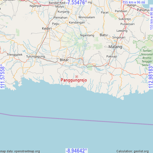
Panggungrejo GPS coordinates[2]
8° 15' 4.32" South, 112° 16' 43.32" East
| Map corner | latitude | longitude |
|---|---|---|
| Upper-left | -7.55476°, | 111.57558° |
| Center: | -8.2512°, | 112.2787° |
| Lower-right: | -8.94642°, | 112.98183° |
| Map W x H: | 154.7×154.7 km | = 96.1×96.1mi |
| max Lat: | 5.88969° ⇑74.3% North |
| Panggungrejo: | -8.2512° |
| min Lat: | ⇓25.7% South -10.934° |
| min Long | Panggungrejo | max Long |
| 95.1345° | 112.2787° | 140.9419° |
| W 51.9%⇐ | ⇒48.1% E |
Elevation
Elevation of Panggungrejo is 257 m = 843 ft, and this is 27.3 m = 90 ft above average elevation for this country.
| Max E: |
3185 m = 10449 ft | 32.5% |
| Panggungrejo | 257 m 843 ft | |
| Avg. | 229.7 m = 754 ft | |
Min E: |
-1 m = -3 ft | 67.5% |
See also: Indonesia elevation on elevation.city.
Geographical zone
Panggungrejo is located in South Torrid zone (between Equator and Tropic of Capricorn). Distance of Equator is 917.4 km =570 mi to North.| Distance of | km | miles | from Panggungrejo |
|---|---|---|---|
| Equator | 917.4 | 570 | to North |
| Tropic Capricorn | 1688.5 | 1049.2 | to South |
| Antarctic Circle | 6483.7 | 4028.8 | to South |
| South Pole | 9089.6 | 5648 | to South |


Nearby cities:
15 places around Panggungrejo: (largest is in red/bold)
• Bacem
8.1 km =5 mi,  320°
320°
• Balerejo
2.4 km =1.5 mi,  98°
98°
• Becirto
4.9 km =3 mi,  304°
304°
• Binangun
6.6 km =4.1 mi,  73°
73°
• Kaligambir
3.1 km =1.9 mi,  185°
185°
• Ngadipuro
5.7 km =3.5 mi,  247°
247°
• Ngeni
7.6 km =4.7 mi,  267°
267°
• Panggungasri
5 km =3.1 mi,  22°
22°
• Panggungwinong
1.7 km =1.1 mi,  37°
37°
• Purworejo
5.2 km =3.2 mi,  111°
111°
• Rampalombo
6 km =3.7 mi,  345°
345°
• Salamrejo
4.9 km =3 mi,  54°
54°
• Serang
7.6 km =4.7 mi,  213°
213°
• Sumberarum
6.7 km =4.2 mi,  87°
87°
• Tulungrejo
6 km =3.7 mi, 109°
Sources, notices
• [Note1] Compared only with cities in Indonesia existing in our database
• [Src1] Map data: © OpenStreetMap contributors (CC-BY-SA)
• [Src2] Other city data from geonames.org with taken over terms of usage.
• [Src3] Geographical zone / Annual Mean Temperature by Robert A. Rohde @ Wikipedia
