Ngembo geodata
Ngembo (East Java) is a seat of a fourth-order administrative division; located in Indonesia in Asia/Jakarta (GMT+7) time zone. In our database, there are 407 cities with bigger population. Compared to other cities in Indonesia, 72% of cities are located further ↓South; 55% of cities are located further ←West and 97.2% of cities have higher elevation than Ngembo. Note1


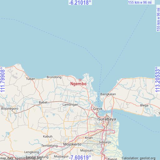
Ngembo GPS coordinates[2]
6° 54' 31.32" South, 112° 30' 7.92" East
| Map corner | latitude | longitude |
|---|---|---|
| Upper-left | -6.21018°, | 111.79908° |
| Center: | -6.9087°, | 112.5022° |
| Lower-right: | -7.60619°, | 113.20533° |
| Map W x H: | 155.2×155.2 km | = 96.4×96.4mi |
| max Lat: | 5.88969° ⇑28% North |
| Ngembo: | -6.9087° |
| min Lat: | ⇓72% South -10.934° |
| min Long | Ngembo | max Long |
| 95.1345° | 112.5022° | 140.9419° |
| W 55%⇐ | ⇒45% E |
Elevation
Elevation of Ngembo is 6 m = 20 ft, and this is 223.7 m = 734 ft below average elevation for this country.
| Max E: |
3185 m = 10449 ft | 97.2% |
| Avg. | 229.7 m = 754 ft | |
| Ngembo | 6 m = 20 ft | |
Min E: |
-1 m = -3 ft | 2.8% |
See also: Indonesia elevation on elevation.city.
Geographical zone
Ngembo is located in South Torrid zone (between Equator and Tropic of Capricorn). Distance of Equator is 768.2 km =477.3 mi to North.| Distance of | km | miles | from Ngembo |
|---|---|---|---|
| Equator | 768.2 | 477.3 | to North |
| Tropic Capricorn | 1837.7 | 1141.9 | to South |
| Antarctic Circle | 6633 | 4121.6 | to South |
| South Pole | 9238.9 | 5740.8 | to South |


Nearby cities:
15 places around Ngembo: (largest is in red/bold)
• Banyulegi
3.2 km =2 mi,  97°
97°
• Banyutengah
5.8 km =3.6 mi,  288°
288°
• Campurrejo
6.1 km =3.8 mi,  296°
296°
• Canga’an
1.5 km =0.9 mi,  164°
164°
• Delegan
4.5 km =2.8 mi,  281°
281°
• Doudo
5.3 km =3.3 mi,  183°
183°
• Gosari
3.5 km =2.2 mi,  166°
166°
• Kebonagung
5.1 km =3.2 mi,  139°
139°
• Krajan Pangkah Kulon
5.8 km =3.6 mi, 97°
• Prupuh
4.9 km =3 mi,  264°
264°
• Sekapuk
5.1 km =3.2 mi, 175°
• Ujungpangkah
5.9 km =3.7 mi, 98°
• Waru Lor
6 km =3.7 mi, 297°
• Watuguling
5.5 km =3.4 mi, 258°
• Wotan
5.9 km =3.7 mi,  197°
197°
Sources, notices
• [Note1] Compared only with cities in Indonesia existing in our database
• [Src1] Map data: © OpenStreetMap contributors (CC-BY-SA)
• [Src2] Other city data from geonames.org with taken over terms of usage.
• [Src3] Geographical zone / Annual Mean Temperature by Robert A. Rohde @ Wikipedia
