Serah geodata
Serah (East Java) is a seat of a fourth-order administrative division; located in Indonesia in Asia/Jakarta (GMT+7) time zone. In our database, there are 407 cities with bigger population. Compared to other cities in Indonesia, 69.6% of cities are located further ↓South; 54.1% of cities are located further ←West and 66.1% of cities have higher elevation than Serah. Note1


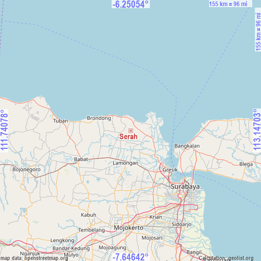
Serah GPS coordinates[2]
6° 56' 56.4" South, 112° 26' 38.04" East
| Map corner | latitude | longitude |
|---|---|---|
| Upper-left | -6.25054°, | 111.74078° |
| Center: | -6.949°, | 112.4439° |
| Lower-right: | -7.64642°, | 113.14703° |
| Map W x H: | 155.2×155.2 km | = 96.4×96.4mi |
| max Lat: | 5.88969° ⇑30.4% North |
| Serah: | -6.949° |
| min Lat: | ⇓69.6% South -10.934° |
| min Long | Serah | max Long |
| 95.1345° | 112.4439° | 140.9419° |
| W 54.1%⇐ | ⇒45.9% E |
Elevation
Elevation of Serah is 40 m = 131 ft, and this is 189.7 m = 622 ft below average elevation for this country.
| Max E: |
3185 m = 10449 ft | 66.1% |
| Avg. | 229.7 m = 754 ft | |
| Serah | 40 m = 131 ft | |
Min E: |
-1 m = -3 ft | 33.9% |
See also: Indonesia elevation on elevation.city.
Geographical zone
Serah is located in South Torrid zone (between Equator and Tropic of Capricorn). Distance of Equator is 772.7 km =480.1 mi to North.| Distance of | km | miles | from Serah |
|---|---|---|---|
| Equator | 772.7 | 480.1 | to North |
| Tropic Capricorn | 1833.3 | 1139.2 | to South |
| Antarctic Circle | 6628.5 | 4118.8 | to South |
| South Pole | 9234.4 | 5738 | to South |


Nearby cities:
15 places around Serah: (largest is in red/bold)
• Banyubang
4.1 km =2.5 mi,  308°
308°
• Gampeng
1.7 km =1.1 mi,  35°
35°
• Jetis
3.4 km =2.1 mi,  201°
201°
• Ketanen
2.7 km =1.7 mi,  354°
354°
• Lowayu
3.9 km =2.4 mi,  224°
224°
• Mentaras
3.6 km =2.2 mi,  174°
174°
• Mojopetung
4.4 km =2.7 mi,  142°
142°
• Pantenan
3.3 km =2.1 mi, 348°
• Prupuh
4.3 km =2.7 mi,  20°
20°
• Siwalan
1.5 km =0.9 mi,  316°
316°
• Sukodono
1.8 km =1.1 mi,  127°
127°
• Sumurber
1.7 km =1.1 mi,  268°
268°
• Takerharjo
3.7 km =2.3 mi,  284°
284°
• Tebuwung
3.6 km =2.2 mi,  187°
187°
• Watuguling
3.5 km =2.2 mi, 16°
Sources, notices
• [Note1] Compared only with cities in Indonesia existing in our database
• [Src1] Map data: © OpenStreetMap contributors (CC-BY-SA)
• [Src2] Other city data from geonames.org with taken over terms of usage.
• [Src3] Geographical zone / Annual Mean Temperature by Robert A. Rohde @ Wikipedia
