Banteng geodata
Banteng (Central Java) is a seat of a fourth-order administrative division; located in Indonesia in Asia/Jakarta (GMT+7) time zone. In our database, there are 407 cities with bigger population. Compared to other cities in Indonesia, 82.7% of cities are located further ↓South; 64.8% of cities are located further →East and 55.7% of cities have higher elevation than Banteng. Note1


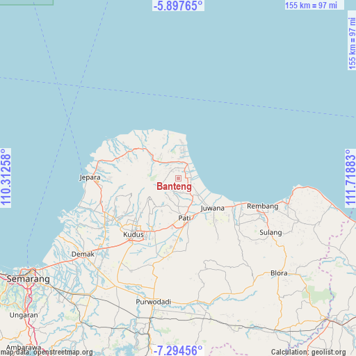
Banteng GPS coordinates[2]
6° 35' 47.76" South, 111° 0' 56.52" East
| Map corner | latitude | longitude |
|---|---|---|
| Upper-left | -5.89765°, | 110.31258° |
| Center: | -6.5966°, | 111.0157° |
| Lower-right: | -7.29456°, | 111.71883° |
| Map W x H: | 155.3×155.3 km | = 96.5×96.5mi |
| max Lat: | 5.88969° ⇑17.3% North |
| Banteng: | -6.5966° |
| min Lat: | ⇓82.7% South -10.934° |
| min Long | Banteng | max Long |
| 95.1345° | 111.0157° | 140.9419° |
| W 35.2%⇐ | ⇒64.8% E |
Elevation
Elevation of Banteng is 80 m = 262 ft, and this is 149.7 m = 491 ft below average elevation for this country.
| Max E: |
3185 m = 10449 ft | 55.7% |
| Avg. | 229.7 m = 754 ft | |
| Banteng | 80 m = 262 ft | |
Min E: |
-1 m = -3 ft | 44.3% |
See also: Indonesia elevation on elevation.city.
Geographical zone
Banteng is located in South Torrid zone (between Equator and Tropic of Capricorn). Distance of Equator is 733.5 km =455.8 mi to North.| Distance of | km | miles | from Banteng |
|---|---|---|---|
| Equator | 733.5 | 455.8 | to North |
| Tropic Capricorn | 1872.4 | 1163.5 | to South |
| Antarctic Circle | 6667.7 | 4143.1 | to South |
| South Pole | 9273.6 | 5762.3 | to South |


Nearby cities:
15 places around Banteng: (largest is in red/bold)
• Bancaran
3.6 km =2.2 mi,  57°
57°
• Cabak Satu
4 km =2.5 mi,  217°
217°
• Drajak
3.5 km =2.2 mi,  32°
32°
• Golong
4.4 km =2.7 mi,  0°
0°
• Kedung
3.1 km =1.9 mi,  94°
94°
• Krajan Gajihan
2.4 km =1.5 mi,  319°
319°
• Krajan Kedungsari
3.7 km =2.3 mi,  46°
46°
• Krajan Waturoyo
4.5 km =2.8 mi, 87°
• Mrican
2.8 km =1.7 mi,  83°
83°
• Ngetuk
3.4 km =2.1 mi,  358°
358°
• Pesagen
0.7 km =0.4 mi,  201°
201°
• Sumber
2.6 km =1.6 mi,  134°
134°
• Suwatu
3.9 km =2.4 mi,  192°
192°
• Tanggung
4.3 km =2.7 mi,  40°
40°
• Tegalarum
1.6 km =1 mi, 198°
Sources, notices
• [Note1] Compared only with cities in Indonesia existing in our database
• [Src1] Map data: © OpenStreetMap contributors (CC-BY-SA)
• [Src2] Other city data from geonames.org with taken over terms of usage.
• [Src3] Geographical zone / Annual Mean Temperature by Robert A. Rohde @ Wikipedia
