Kebon geodata
Kebon (East Java) is a seat of a fourth-order administrative division; located in Indonesia in Asia/Jakarta (GMT+7) time zone. In our database, there are 407 cities with bigger population. Compared to other cities in Indonesia, 55.8% of cities are located further ↓South; 62.2% of cities are located further ←West and 89% of cities have higher elevation than Kebon. Note1


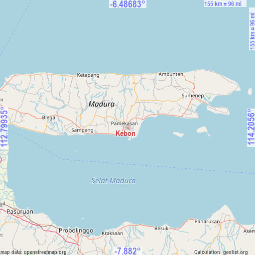
Kebon GPS coordinates[2]
7° 11' 5.82" South, 113° 30' 8.892" East
| Map corner | latitude | longitude |
|---|---|---|
| Upper-left | -6.48683°, | 112.79935° |
| Center: | -7.18495°, | 113.50247° |
| Lower-right: | -7.882°, | 114.2056° |
| Map W x H: | 155.1×155.1 km | = 96.4×96.4mi |
| max Lat: | 5.88969° ⇑44.2% North |
| Kebon: | -7.18495° |
| min Lat: | ⇓55.8% South -10.934° |
| min Long | Kebon | max Long |
| 95.1345° | 113.50247° | 140.9419° |
| W 62.2%⇐ | ⇒37.8% E |
Elevation
Elevation of Kebon is 11 m = 36 ft, and this is 218.7 m = 718 ft below average elevation for this country.
| Max E: |
3185 m = 10449 ft | 89% |
| Avg. | 229.7 m = 754 ft | |
| Kebon | 11 m = 36 ft | |
Min E: |
-1 m = -3 ft | 11% |
See also: Indonesia elevation on elevation.city.
Geographical zone
Kebon is located in South Torrid zone (between Equator and Tropic of Capricorn). Distance of Equator is 798.9 km =496.4 mi to North.| Distance of | km | miles | from Kebon |
|---|---|---|---|
| Equator | 798.9 | 496.4 | to North |
| Tropic Capricorn | 1807 | 1122.8 | to South |
| Antarctic Circle | 6602.3 | 4102.5 | to South |
| South Pole | 9208.2 | 5721.7 | to South |


Nearby cities:
15 places around Kebon: (largest is in red/bold)
• Biris Daja
4 km =2.5 mi,  28°
28°
• Bulung
3.1 km =1.9 mi,  15°
15°
• Bunder
3 km =1.9 mi,  93°
93°
• Dorbuk Utara
0.9 km =0.6 mi,  171°
171°
• Karangdalam
1.2 km =0.7 mi,  111°
111°
• Lobuk
3.4 km =2.1 mi, 31°
• Mor Laok
4.6 km =2.9 mi,  162°
162°
• Morsoksok
2.6 km =1.6 mi,  191°
191°
• Mungging
3.9 km =2.4 mi,  123°
123°
• Murtajih
2.1 km =1.3 mi, 20°
• Ombul
3.8 km =2.4 mi,  351°
351°
• Pademawu
2.6 km =1.6 mi, 93°
• Pamekasan
4.4 km =2.7 mi,  315°
315°
• Utara
1.7 km =1.1 mi,  202°
202°
• Utara
1.9 km =1.2 mi, 347°
Sources, notices
• [Note1] Compared only with cities in Indonesia existing in our database
• [Src1] Map data: © OpenStreetMap contributors (CC-BY-SA)
• [Src2] Other city data from geonames.org with taken over terms of usage.
• [Src3] Geographical zone / Annual Mean Temperature by Robert A. Rohde @ Wikipedia
