Baih geodata
Baih (East Java) is a seat of a fourth-order administrative division; located in Indonesia in Asia/Jakarta (GMT+7) time zone. In our database, there are 407 cities with bigger population. Compared to other cities in Indonesia, 68.3% of cities are located further ↓South; 59.5% of cities are located further ←West and 54.5% of cities have lower elevation than Baih. Note1


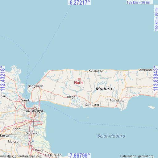
Baih GPS coordinates[2]
6° 58' 14.16" South, 113° 8' 7.08" East
| Map corner | latitude | longitude |
|---|---|---|
| Upper-left | -6.27217°, | 112.43218° |
| Center: | -6.9706°, | 113.1353° |
| Lower-right: | -7.66799°, | 113.83843° |
| Map W x H: | 155.2×155.2 km | = 96.4×96.4mi |
| max Lat: | 5.88969° ⇑31.7% North |
| Baih: | -6.9706° |
| min Lat: | ⇓68.3% South -10.934° |
| min Long | Baih | max Long |
| 95.1345° | 113.1353° | 140.9419° |
| W 59.5%⇐ | ⇒40.5% E |
Elevation
Elevation of Baih is 122 m = 400 ft, and this is 107.7 m = 353 ft below average elevation for this country.
| Max E: |
3185 m = 10449 ft | 45.5% |
| Avg. | 229.7 m = 754 ft | |
| Baih | 122 m = 400 ft | |
Min E: |
-1 m = -3 ft | 54.5% |
See also: Indonesia elevation on elevation.city.
Geographical zone
Baih is located in South Torrid zone (between Equator and Tropic of Capricorn). Distance of Equator is 775.1 km =481.6 mi to North.| Distance of | km | miles | from Baih |
|---|---|---|---|
| Equator | 775.1 | 481.6 | to North |
| Tropic Capricorn | 1830.9 | 1137.7 | to South |
| Antarctic Circle | 6626.1 | 4117.3 | to South |
| South Pole | 9232 | 5736.5 | to South |


Nearby cities:
15 places around Baih: (largest is in red/bold)
• Bateke
4.5 km =2.8 mi,  79°
79°
• Dangbigih
5.6 km =3.5 mi,  250°
250°
• Dangbigih
6.6 km =4.1 mi,  270°
270°
• Mandeman Daya
8.2 km =5.1 mi,  16°
16°
• Minian
6.1 km =3.8 mi,  3°
3°
• Morbatoh
6.9 km =4.3 mi,  29°
29°
• Pandian
6.1 km =3.8 mi,  9°
9°
• Sebegen
6.3 km =3.9 mi,  66°
66°
• Sokadan
7.6 km =4.7 mi,  320°
320°
• Sreseh
8.1 km =5 mi,  285°
285°
• Tanahmerah
7.3 km =4.5 mi,  333°
333°
• Tapaan Timur
3.8 km =2.4 mi,  57°
57°
• Taposan
4.5 km =2.8 mi, 71°
• Tenggina Daya
6.9 km =4.3 mi, 79°
• Tiara
3.4 km =2.1 mi,  357°
357°
Sources, notices
• [Note1] Compared only with cities in Indonesia existing in our database
• [Src1] Map data: © OpenStreetMap contributors (CC-BY-SA)
• [Src2] Other city data from geonames.org with taken over terms of usage.
• [Src3] Geographical zone / Annual Mean Temperature by Robert A. Rohde @ Wikipedia
