Tenggina Daya geodata
Tenggina Daya (East Java) is a seat of a fourth-order administrative division; located in Indonesia in Asia/Jakarta (GMT+7) time zone. In our database, there are 407 cities with bigger population. Compared to other cities in Indonesia, 69.1% of cities are located further ↓South; 59.9% of cities are located further ←West and 61.1% of cities have higher elevation than Tenggina Daya. Note1


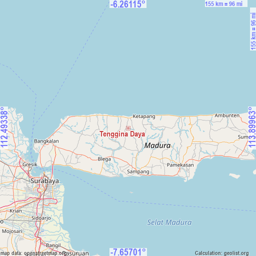
Tenggina Daya GPS coordinates[2]
6° 57' 34.56" South, 113° 11' 47.4" East
| Map corner | latitude | longitude |
|---|---|---|
| Upper-left | -6.26115°, | 112.49338° |
| Center: | -6.9596°, | 113.1965° |
| Lower-right: | -7.65701°, | 113.89963° |
| Map W x H: | 155.2×155.2 km | = 96.4×96.4mi |
| max Lat: | 5.88969° ⇑30.9% North |
| Tenggina Daya: | -6.9596° |
| min Lat: | ⇓69.1% South -10.934° |
| min Long | Tenggina Daya | max Long |
| 95.1345° | 113.1965° | 140.9419° |
| W 59.9%⇐ | ⇒40.1% E |
Elevation
Elevation of Tenggina Daya is 55 m = 180 ft, and this is 174.7 m = 573 ft below average elevation for this country.
| Max E: |
3185 m = 10449 ft | 61.1% |
| Avg. | 229.7 m = 754 ft | |
| Tenggina Daya | 55 m = 180 ft | |
Min E: |
-1 m = -3 ft | 38.9% |
See also: Indonesia elevation on elevation.city.
Geographical zone
Tenggina Daya is located in South Torrid zone (between Equator and Tropic of Capricorn). Distance of Equator is 773.8 km =480.8 mi to North.| Distance of | km | miles | from Tenggina Daya |
|---|---|---|---|
| Equator | 773.8 | 480.8 | to North |
| Tropic Capricorn | 1832.1 | 1138.4 | to South |
| Antarctic Circle | 6627.3 | 4118 | to South |
| South Pole | 9233.2 | 5737.2 | to South |


Nearby cities:
15 places around Tenggina Daya: (largest is in red/bold)
• Baih
6.9 km =4.3 mi,  259°
259°
• Bateke
2.4 km =1.5 mi, 261°
• Galis
2.9 km =1.8 mi,  107°
107°
• Kapasan
6.8 km =4.2 mi,  350°
350°
• Korbukor
4 km =2.5 mi, 353°
• Masaran
6.6 km =4.1 mi,  36°
36°
• Morbatoh
5.8 km =3.6 mi,  324°
324°
• Nepa
7.3 km =4.5 mi,  15°
15°
• Ramaram
7.4 km =4.6 mi,  337°
337°
• Sebegen
1.6 km =1 mi, 322°
• Tapaan Timur
3.7 km =2.3 mi,  282°
282°
• Taposan
2.5 km =1.6 mi,  274°
274°
• Tebanah
4.3 km =2.7 mi,  11°
11°
• Tiara
7.2 km =4.5 mi,  287°
287°
• Tlagah Timur
5.2 km =3.2 mi, 19°
Sources, notices
• [Note1] Compared only with cities in Indonesia existing in our database
• [Src1] Map data: © OpenStreetMap contributors (CC-BY-SA)
• [Src2] Other city data from geonames.org with taken over terms of usage.
• [Src3] Geographical zone / Annual Mean Temperature by Robert A. Rohde @ Wikipedia
