Jalgung geodata
Jalgung (East Java) is a seat of a fourth-order administrative division; located in Indonesia in Asia/Jakarta (GMT+7) time zone. In our database, there are 407 cities with bigger population. Compared to other cities in Indonesia, 66.4% of cities are located further ↓South; 60.8% of cities are located further ←West and 56.3% of cities have higher elevation than Jalgung. Note1


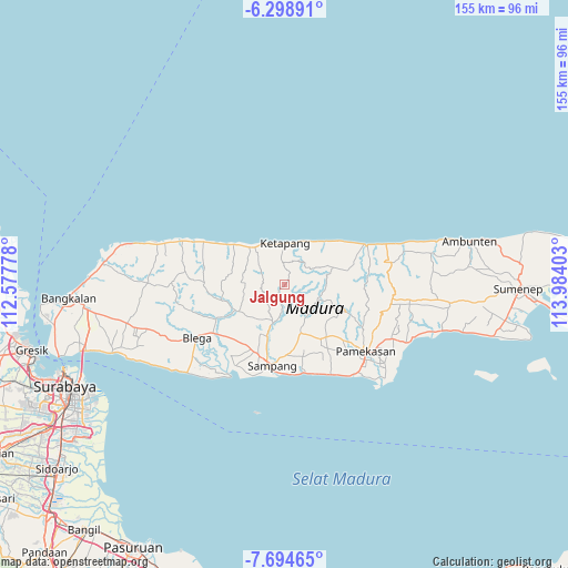
Jalgung GPS coordinates[2]
6° 59' 50.28" South, 113° 16' 51.24" East
| Map corner | latitude | longitude |
|---|---|---|
| Upper-left | -6.29891°, | 112.57778° |
| Center: | -6.9973°, | 113.2809° |
| Lower-right: | -7.69465°, | 113.98403° |
| Map W x H: | 155.2×155.2 km | = 96.4×96.4mi |
| max Lat: | 5.88969° ⇑33.6% North |
| Jalgung: | -6.9973° |
| min Lat: | ⇓66.4% South -10.934° |
| min Long | Jalgung | max Long |
| 95.1345° | 113.2809° | 140.9419° |
| W 60.8%⇐ | ⇒39.2% E |
Elevation
Elevation of Jalgung is 77 m = 253 ft, and this is 152.7 m = 501 ft below average elevation for this country.
| Max E: |
3185 m = 10449 ft | 56.3% |
| Avg. | 229.7 m = 754 ft | |
| Jalgung | 77 m = 253 ft | |
Min E: |
-1 m = -3 ft | 43.7% |
See also: Indonesia elevation on elevation.city.
Geographical zone
Jalgung is located in South Torrid zone (between Equator and Tropic of Capricorn). Distance of Equator is 778 km =483.4 mi to North.| Distance of | km | miles | from Jalgung |
|---|---|---|---|
| Equator | 778 | 483.4 | to North |
| Tropic Capricorn | 1827.9 | 1135.8 | to South |
| Antarctic Circle | 6623.1 | 4115.4 | to South |
| South Pole | 9229 | 5734.6 | to South |


Nearby cities:
15 places around Jalgung: (largest is in red/bold)
• Bungkeduk
11.3 km =7 mi,  70°
70°
• Dampol
9.9 km =6.2 mi,  340°
340°
• Derbing
2.5 km =1.6 mi,  275°
275°
• Galis
7.4 km =4.6 mi,  296°
296°
• Kemereh
10.5 km =6.5 mi,  53°
53°
• Kemiri Daya
3.2 km =2 mi, 341°
• Lekedalem
5.4 km =3.4 mi, 67°
• Masaran
10.9 km =6.8 mi,  330°
330°
• Nanger
3.2 km =2 mi,  61°
61°
• Robatal
0.4 km =0.2 mi,  193°
193°
• Sorren Daya
8.5 km =5.3 mi,  345°
345°
• Taman
9.7 km =6 mi,  358°
358°
• Tengah
6.1 km =3.8 mi,  22°
22°
• Tengah
6.2 km =3.9 mi,  3°
3°
• Tenggina Daya
10.2 km =6.3 mi,  294°
294°
Sources, notices
• [Note1] Compared only with cities in Indonesia existing in our database
• [Src1] Map data: © OpenStreetMap contributors (CC-BY-SA)
• [Src2] Other city data from geonames.org with taken over terms of usage.
• [Src3] Geographical zone / Annual Mean Temperature by Robert A. Rohde @ Wikipedia
