Nanger geodata
Nanger (East Java) is a seat of a fourth-order administrative division; located in Indonesia in Asia/Jakarta (GMT+7) time zone. In our database, there are 407 cities with bigger population. Compared to other cities in Indonesia, 67.4% of cities are located further ↓South; 60.9% of cities are located further ←West and 56.5% of cities have lower elevation than Nanger. Note1


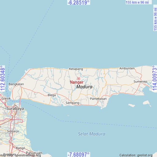
Nanger GPS coordinates[2]
6° 59' 0.96" South, 113° 18' 23.76" East
| Map corner | latitude | longitude |
|---|---|---|
| Upper-left | -6.28519°, | 112.60348° |
| Center: | -6.9836°, | 113.3066° |
| Lower-right: | -7.68097°, | 114.00973° |
| Map W x H: | 155.2×155.2 km | = 96.4×96.4mi |
| max Lat: | 5.88969° ⇑32.6% North |
| Nanger: | -6.9836° |
| min Lat: | ⇓67.4% South -10.934° |
| min Long | Nanger | max Long |
| 95.1345° | 113.3066° | 140.9419° |
| W 60.9%⇐ | ⇒39.1% E |
Elevation
Elevation of Nanger is 134 m = 440 ft, and this is 95.7 m = 314 ft below average elevation for this country.
| Max E: |
3185 m = 10449 ft | 43.5% |
| Avg. | 229.7 m = 754 ft | |
| Nanger | 134 m = 440 ft | |
Min E: |
-1 m = -3 ft | 56.5% |
See also: Indonesia elevation on elevation.city.
Geographical zone
Nanger is located in South Torrid zone (between Equator and Tropic of Capricorn). Distance of Equator is 776.5 km =482.5 mi to North.| Distance of | km | miles | from Nanger |
|---|---|---|---|
| Equator | 776.5 | 482.5 | to North |
| Tropic Capricorn | 1829.4 | 1136.7 | to South |
| Antarctic Circle | 6624.7 | 4116.4 | to South |
| South Pole | 9230.6 | 5735.6 | to South |


Nearby cities:
15 places around Nanger: (largest is in red/bold)
• Bungkeduk
8.2 km =5.1 mi,  73°
73°
• Derbing
5.4 km =3.4 mi,  256°
256°
• Duwakkandung
8.8 km =5.5 mi,  96°
96°
• Galis
9.6 km =6 mi,  280°
280°
• Gilin
9.8 km =6.1 mi,  4°
4°
• Jalgung
3.2 km =2 mi,  241°
241°
• Kemereh
7.3 km =4.5 mi,  50°
50°
• Kemiri Daya
4.1 km =2.5 mi,  291°
291°
• Lekedalem
2.2 km =1.4 mi,  76°
76°
• Ragung
8.3 km =5.2 mi,  57°
57°
• Robatal
3.5 km =2.2 mi, 236°
• Sorren Daya
8.4 km =5.2 mi,  323°
323°
• Taman
8.7 km =5.4 mi,  339°
339°
• Tengah
4.1 km =2.5 mi,  353°
353°
• Tengah
5.3 km =3.3 mi,  332°
332°
Sources, notices
• [Note1] Compared only with cities in Indonesia existing in our database
• [Src1] Map data: © OpenStreetMap contributors (CC-BY-SA)
• [Src2] Other city data from geonames.org with taken over terms of usage.
• [Src3] Geographical zone / Annual Mean Temperature by Robert A. Rohde @ Wikipedia
