Komes geodata
Komes (East Java) is a seat of a fourth-order administrative division; located in Indonesia in Asia/Jakarta (GMT+7) time zone. In our database, there are 407 cities with bigger population. Compared to other cities in Indonesia, 67.9% of cities are located further ↓South; 63.8% of cities are located further ←West and 64.2% of cities have lower elevation than Komes. Note1


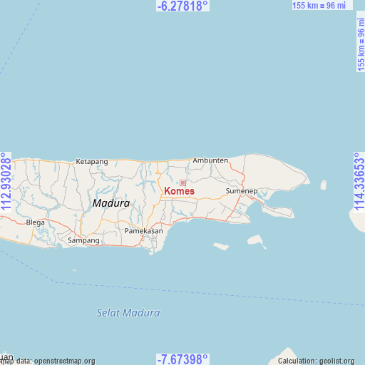
Komes GPS coordinates[2]
6° 58' 35.76" South, 113° 38' 0.24" East
| Map corner | latitude | longitude |
|---|---|---|
| Upper-left | -6.27818°, | 112.93028° |
| Center: | -6.9766°, | 113.6334° |
| Lower-right: | -7.67398°, | 114.33653° |
| Map W x H: | 155.2×155.2 km | = 96.4×96.4mi |
| max Lat: | 5.88969° ⇑32.1% North |
| Komes: | -6.9766° |
| min Lat: | ⇓67.9% South -10.934° |
| min Long | Komes | max Long |
| 95.1345° | 113.6334° | 140.9419° |
| W 63.8%⇐ | ⇒36.2% E |
Elevation
Elevation of Komes is 211 m = 692 ft, and this is 18.7 m = 61 ft below average elevation for this country.
| Max E: |
3185 m = 10449 ft | 35.8% |
| Avg. | 229.7 m = 754 ft | |
| Komes | 211 m = 692 ft | |
Min E: |
-1 m = -3 ft | 64.2% |
See also: Indonesia elevation on elevation.city.
Geographical zone
Komes is located in South Torrid zone (between Equator and Tropic of Capricorn). Distance of Equator is 775.7 km =482 mi to North.| Distance of | km | miles | from Komes |
|---|---|---|---|
| Equator | 775.7 | 482 | to North |
| Tropic Capricorn | 1830.2 | 1137.2 | to South |
| Antarctic Circle | 6625.4 | 4116.8 | to South |
| South Pole | 9231.3 | 5736.1 | to South |


Nearby cities:
15 places around Komes: (largest is in red/bold)
• Bangrat
7.1 km =4.4 mi,  174°
174°
• Banlapa
6.9 km =4.3 mi,  155°
155°
• Bilamabuk
1.4 km =0.9 mi,  130°
130°
• Den Timur
5 km =3.1 mi,  73°
73°
• Duko
6.5 km =4 mi,  349°
349°
• Grujugan
6.1 km =3.8 mi,  198°
198°
• Gunung
7.1 km =4.4 mi,  233°
233°
• Kokembang
3.2 km =2 mi,  32°
32°
• Langdulang
4.1 km =2.5 mi,  314°
314°
• Lanpelan
3.9 km =2.4 mi,  261°
261°
• Laokgunung
6.4 km =4 mi,  298°
298°
• Masaran
4.4 km =2.7 mi,  254°
254°
• Nangger
6.2 km =3.9 mi,  180°
180°
• Samparna
6.7 km =4.2 mi,  99°
99°
• Toroy
7.1 km =4.4 mi,  337°
337°
Sources, notices
• [Note1] Compared only with cities in Indonesia existing in our database
• [Src1] Map data: © OpenStreetMap contributors (CC-BY-SA)
• [Src2] Other city data from geonames.org with taken over terms of usage.
• [Src3] Geographical zone / Annual Mean Temperature by Robert A. Rohde @ Wikipedia
