Lanpelan geodata
Lanpelan (East Java) is a seat of a fourth-order administrative division; located in Indonesia in Asia/Jakarta (GMT+7) time zone. In our database, there are 407 cities with bigger population. Compared to other cities in Indonesia, 67.4% of cities are located further ↓South; 63.5% of cities are located further ←West and 56.4% of cities have lower elevation than Lanpelan. Note1


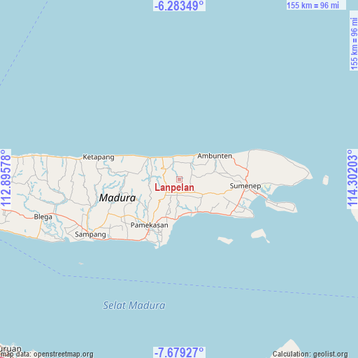
Lanpelan GPS coordinates[2]
6° 58' 54.84" South, 113° 35' 56.04" East
| Map corner | latitude | longitude |
|---|---|---|
| Upper-left | -6.28349°, | 112.89578° |
| Center: | -6.9819°, | 113.5989° |
| Lower-right: | -7.67927°, | 114.30203° |
| Map W x H: | 155.2×155.2 km | = 96.4×96.4mi |
| max Lat: | 5.88969° ⇑32.6% North |
| Lanpelan: | -6.9819° |
| min Lat: | ⇓67.4% South -10.934° |
| min Long | Lanpelan | max Long |
| 95.1345° | 113.5989° | 140.9419° |
| W 63.5%⇐ | ⇒36.5% E |
Elevation
Elevation of Lanpelan is 133 m = 436 ft, and this is 96.7 m = 317 ft below average elevation for this country.
| Max E: |
3185 m = 10449 ft | 43.6% |
| Avg. | 229.7 m = 754 ft | |
| Lanpelan | 133 m = 436 ft | |
Min E: |
-1 m = -3 ft | 56.4% |
See also: Indonesia elevation on elevation.city.
Geographical zone
Lanpelan is located in South Torrid zone (between Equator and Tropic of Capricorn). Distance of Equator is 776.3 km =482.4 mi to North.| Distance of | km | miles | from Lanpelan |
|---|---|---|---|
| Equator | 776.3 | 482.4 | to North |
| Tropic Capricorn | 1829.6 | 1136.9 | to South |
| Antarctic Circle | 6624.9 | 4116.5 | to South |
| South Pole | 9230.7 | 5735.7 | to South |


Nearby cities:
15 places around Lanpelan: (largest is in red/bold)
• Ba’rigi
6.5 km =4 mi,  176°
176°
• Bilamabuk
4.9 km =3 mi,  93°
93°
• Grujugan
5.5 km =3.4 mi,  160°
160°
• Gunung
4.1 km =2.5 mi,  207°
207°
• Gunungtengah
5.5 km =3.4 mi,  289°
289°
• Kokembang
6.4 km =4 mi,  59°
59°
• Komes
3.9 km =2.4 mi,  81°
81°
• Langdulang
3.6 km =2.2 mi,  13°
13°
• Laokgunung
4.1 km =2.5 mi,  333°
333°
• Masaran
0.7 km =0.4 mi,  217°
217°
• Nangger
6.8 km =4.2 mi,  146°
146°
• Palalang
6.3 km =3.9 mi, 206°
• Parengan Laok
5.7 km =3.5 mi,  187°
187°
• Pregi
6.5 km =4 mi,  270°
270°
• Tenggina
4.2 km =2.6 mi,  243°
243°
Sources, notices
• [Note1] Compared only with cities in Indonesia existing in our database
• [Src1] Map data: © OpenStreetMap contributors (CC-BY-SA)
• [Src2] Other city data from geonames.org with taken over terms of usage.
• [Src3] Geographical zone / Annual Mean Temperature by Robert A. Rohde @ Wikipedia
