Candi geodata
Candi (East Java) is a seat of a fourth-order administrative division; located in Indonesia in Asia/Jakarta (GMT+7) time zone. In our database, there are 407 cities with bigger population. Compared to other cities in Indonesia, 71.8% of cities are located further ↓South; 64.9% of cities are located further ←West and 60.1% of cities have higher elevation than Candi. Note1


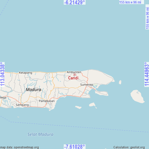
Candi GPS coordinates[2]
6° 54' 46.08" South, 113° 44' 47.4" East
| Map corner | latitude | longitude |
|---|---|---|
| Upper-left | -6.21429°, | 113.04338° |
| Center: | -6.9128°, | 113.7465° |
| Lower-right: | -7.61028°, | 114.44963° |
| Map W x H: | 155.2×155.2 km | = 96.4×96.4mi |
| max Lat: | 5.88969° ⇑28.2% North |
| Candi: | -6.9128° |
| min Lat: | ⇓71.8% South -10.934° |
| min Long | Candi | max Long |
| 95.1345° | 113.7465° | 140.9419° |
| W 64.9%⇐ | ⇒35.1% E |
Elevation
Elevation of Candi is 59 m = 194 ft, and this is 170.7 m = 560 ft below average elevation for this country.
| Max E: |
3185 m = 10449 ft | 60.1% |
| Avg. | 229.7 m = 754 ft | |
| Candi | 59 m = 194 ft | |
Min E: |
-1 m = -3 ft | 39.9% |
See also: Indonesia elevation on elevation.city.
Geographical zone
Candi is located in South Torrid zone (between Equator and Tropic of Capricorn). Distance of Equator is 768.6 km =477.6 mi to North.| Distance of | km | miles | from Candi |
|---|---|---|---|
| Equator | 768.6 | 477.6 | to North |
| Tropic Capricorn | 1837.3 | 1141.6 | to South |
| Antarctic Circle | 6632.5 | 4121.2 | to South |
| South Pole | 9238.4 | 5740.5 | to South |


Nearby cities:
15 places around Candi: (largest is in red/bold)
• Ambuten
2.8 km =1.7 mi,  343°
343°
• Ares Tengah
4.4 km =2.7 mi,  55°
55°
• Bata Tengah
3.5 km =2.2 mi,  77°
77°
• Bukabu
1.4 km =0.9 mi,  25°
25°
• Campor
3.2 km =2 mi, 26°
• Dajalorong
3.7 km =2.3 mi,  137°
137°
• Daleman
2.4 km =1.5 mi,  40°
40°
• Gunong
4.3 km =2.7 mi,  115°
115°
• Gunungtunggal
2 km =1.2 mi,  248°
248°
• Keles Timur
3.7 km =2.3 mi,  125°
125°
• Naekan
1.6 km =1 mi,  201°
201°
• Naikan
0.8 km =0.5 mi, 125°
• Pandan
3.3 km =2.1 mi,  322°
322°
• Pedatar Timur
3.3 km =2.1 mi,  194°
194°
• Salegading
3 km =1.9 mi,  164°
164°
Sources, notices
• [Note1] Compared only with cities in Indonesia existing in our database
• [Src1] Map data: © OpenStreetMap contributors (CC-BY-SA)
• [Src2] Other city data from geonames.org with taken over terms of usage.
• [Src3] Geographical zone / Annual Mean Temperature by Robert A. Rohde @ Wikipedia
