Pedatar Timur geodata
Pedatar Timur (East Java) is a seat of a fourth-order administrative division; located in Indonesia in Asia/Jakarta (GMT+7) time zone. In our database, there are 407 cities with bigger population. Compared to other cities in Indonesia, 70% of cities are located further ↓South; 64.8% of cities are located further ←West and 53.4% of cities have higher elevation than Pedatar Timur. Note1


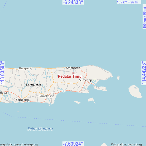
Pedatar Timur GPS coordinates[2]
6° 56' 30.48" South, 113° 44' 20.76" East
| Map corner | latitude | longitude |
|---|---|---|
| Upper-left | -6.24333°, | 113.03598° |
| Center: | -6.9418°, | 113.7391° |
| Lower-right: | -7.63924°, | 114.44223° |
| Map W x H: | 155.2×155.2 km | = 96.4×96.4mi |
| max Lat: | 5.88969° ⇑30% North |
| Pedatar Timur: | -6.9418° |
| min Lat: | ⇓70% South -10.934° |
| min Long | Pedatar Timur | max Long |
| 95.1345° | 113.7391° | 140.9419° |
| W 64.8%⇐ | ⇒35.2% E |
Elevation
Elevation of Pedatar Timur is 91 m = 299 ft, and this is 138.7 m = 455 ft below average elevation for this country.
| Max E: |
3185 m = 10449 ft | 53.4% |
| Avg. | 229.7 m = 754 ft | |
| Pedatar Timur | 91 m = 299 ft | |
Min E: |
-1 m = -3 ft | 46.6% |
See also: Indonesia elevation on elevation.city.
Geographical zone
Pedatar Timur is located in South Torrid zone (between Equator and Tropic of Capricorn). Distance of Equator is 771.9 km =479.6 mi to North.| Distance of | km | miles | from Pedatar Timur |
|---|---|---|---|
| Equator | 771.9 | 479.6 | to North |
| Tropic Capricorn | 1834.1 | 1139.7 | to South |
| Antarctic Circle | 6629.3 | 4119.3 | to South |
| South Pole | 9235.2 | 5738.5 | to South |


Nearby cities:
15 places around Pedatar Timur: (largest is in red/bold)
• Bukabu
4.7 km =2.9 mi,  17°
17°
• Bun Barat
4.8 km =3 mi,  107°
107°
• Candi
3.3 km =2.1 mi,  14°
14°
• Dajalorong
3.3 km =2.1 mi,  80°
80°
• Gunungtunggal
2.7 km =1.7 mi,  337°
337°
• Keles Timur
4 km =2.5 mi,  74°
74°
• Langgulang
4.6 km =2.9 mi,  291°
291°
• Lenteng
1.4 km =0.9 mi,  182°
182°
• Naekan
1.8 km =1.1 mi, 7°
• Naikan
3.1 km =1.9 mi,  28°
28°
• Pakis
4.6 km =2.9 mi,  259°
259°
• Palampal
3.1 km =1.9 mi,  153°
153°
• Rubaru
2.4 km =1.5 mi,  139°
139°
• Salegading
1.6 km =1 mi, 79°
• Timursabah
2.1 km =1.3 mi,  118°
118°
Sources, notices
• [Note1] Compared only with cities in Indonesia existing in our database
• [Src1] Map data: © OpenStreetMap contributors (CC-BY-SA)
• [Src2] Other city data from geonames.org with taken over terms of usage.
• [Src3] Geographical zone / Annual Mean Temperature by Robert A. Rohde @ Wikipedia
