Gunungtunggal geodata
Gunungtunggal (East Java) is a seat of a fourth-order administrative division; located in Indonesia in Asia/Jakarta (GMT+7) time zone. In our database, there are 407 cities with bigger population. Compared to other cities in Indonesia, 71.3% of cities are located further ↓South; 64.7% of cities are located further ←West and 50.6% of cities have lower elevation than Gunungtunggal. Note1


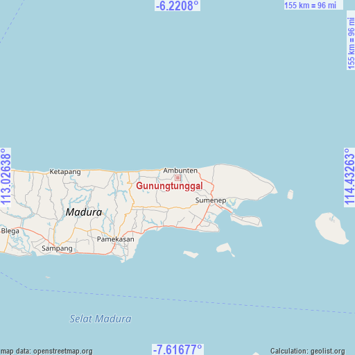
Gunungtunggal GPS coordinates[2]
6° 55' 9.48" South, 113° 43' 46.2" East
| Map corner | latitude | longitude |
|---|---|---|
| Upper-left | -6.2208°, | 113.02638° |
| Center: | -6.9193°, | 113.7295° |
| Lower-right: | -7.61677°, | 114.43263° |
| Map W x H: | 155.2×155.2 km | = 96.4×96.4mi |
| max Lat: | 5.88969° ⇑28.7% North |
| Gunungtunggal: | -6.9193° |
| min Lat: | ⇓71.3% South -10.934° |
| min Long | Gunungtunggal | max Long |
| 95.1345° | 113.7295° | 140.9419° |
| W 64.7%⇐ | ⇒35.3% E |
Elevation
Elevation of Gunungtunggal is 104 m = 341 ft, and this is 125.7 m = 412 ft below average elevation for this country.
| Max E: |
3185 m = 10449 ft | 49.4% |
| Avg. | 229.7 m = 754 ft | |
| Gunungtunggal | 104 m = 341 ft | |
Min E: |
-1 m = -3 ft | 50.6% |
See also: Indonesia elevation on elevation.city.
Geographical zone
Gunungtunggal is located in South Torrid zone (between Equator and Tropic of Capricorn). Distance of Equator is 769.4 km =478.1 mi to North.| Distance of | km | miles | from Gunungtunggal |
|---|---|---|---|
| Equator | 769.4 | 478.1 | to North |
| Tropic Capricorn | 1836.6 | 1141.2 | to South |
| Antarctic Circle | 6631.8 | 4120.8 | to South |
| South Pole | 9237.7 | 5740 | to South |


Nearby cities:
15 places around Gunungtunggal: (largest is in red/bold)
• Ambuten
3.6 km =2.2 mi,  17°
17°
• Bukabu
3.2 km =2 mi,  51°
51°
• Candi
2 km =1.2 mi,  68°
68°
• Dajalorong
4.8 km =3 mi,  114°
114°
• Daleman
4.3 km =2.7 mi, 53°
• Durbugan
3.1 km =1.9 mi,  302°
302°
• Langgulang
3.3 km =2.1 mi,  255°
255°
• Lenteng
4 km =2.5 mi,  165°
165°
• Naekan
1.5 km =0.9 mi,  119°
119°
• Naikan
2.6 km =1.6 mi,  84°
84°
• Pakis
4.8 km =3 mi,  226°
226°
• Pandan
3.4 km =2.1 mi,  357°
357°
• Pedatar Timur
2.7 km =1.7 mi,  157°
157°
• Salegading
3.5 km =2.2 mi,  129°
129°
• Timursabah
4.6 km =2.9 mi,  140°
140°
Sources, notices
• [Note1] Compared only with cities in Indonesia existing in our database
• [Src1] Map data: © OpenStreetMap contributors (CC-BY-SA)
• [Src2] Other city data from geonames.org with taken over terms of usage.
• [Src3] Geographical zone / Annual Mean Temperature by Robert A. Rohde @ Wikipedia
