Campor geodata
Campor (East Java) is a seat of a fourth-order administrative division; located in Indonesia in Asia/Jakarta (GMT+7) time zone. In our database, there are 407 cities with bigger population. Compared to other cities in Indonesia, 73.6% of cities are located further ↓South; 65.1% of cities are located further ←West and 85.2% of cities have higher elevation than Campor. Note1


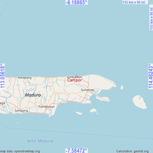
Campor GPS coordinates[2]
6° 53' 13.92" South, 113° 45' 33.48" East
| Map corner | latitude | longitude |
|---|---|---|
| Upper-left | -6.18865°, | 113.05618° |
| Center: | -6.8872°, | 113.7593° |
| Lower-right: | -7.58472°, | 114.46243° |
| Map W x H: | 155.2×155.2 km | = 96.4×96.4mi |
| max Lat: | 5.88969° ⇑26.4% North |
| Campor: | -6.8872° |
| min Lat: | ⇓73.6% South -10.934° |
| min Long | Campor | max Long |
| 95.1345° | 113.7593° | 140.9419° |
| W 65.1%⇐ | ⇒34.9% E |
Elevation
Elevation of Campor is 14 m = 46 ft, and this is 215.7 m = 708 ft below average elevation for this country.
| Max E: |
3185 m = 10449 ft | 85.2% |
| Avg. | 229.7 m = 754 ft | |
| Campor | 14 m = 46 ft | |
Min E: |
-1 m = -3 ft | 14.8% |
See also: Indonesia elevation on elevation.city.
Geographical zone
Campor is located in South Torrid zone (between Equator and Tropic of Capricorn). Distance of Equator is 765.8 km =475.8 mi to North.| Distance of | km | miles | from Campor |
|---|---|---|---|
| Equator | 765.8 | 475.8 | to North |
| Tropic Capricorn | 1840.1 | 1143.4 | to South |
| Antarctic Circle | 6635.4 | 4123 | to South |
| South Pole | 9241.3 | 5742.3 | to South |


Nearby cities:
15 places around Campor: (largest is in red/bold)
• Ambuten
2.2 km =1.4 mi,  266°
266°
• Ares Tengah
2.2 km =1.4 mi,  99°
99°
• Bata Tengah
2.9 km =1.8 mi,  135°
135°
• Betangan
4.9 km =3 mi, 99°
• Bukabu
1.8 km =1.1 mi,  207°
207°
• Candi
3.2 km =2 mi, 206°
• Daleman
1 km =0.6 mi,  172°
172°
• Gunong
5.3 km =3.3 mi,  152°
152°
• Gunungtunggal
4.9 km =3 mi,  222°
222°
• Kaceng
4.9 km =3 mi,  126°
126°
• Lebak
2.9 km =1.8 mi,  88°
88°
• Naekan
4.8 km =3 mi,  204°
204°
• Naikan
3.4 km =2.1 mi,  192°
192°
• Pandan
3.5 km =2.2 mi, 266°
• Tajan
3.7 km =2.3 mi,  108°
108°
Sources, notices
• [Note1] Compared only with cities in Indonesia existing in our database
• [Src1] Map data: © OpenStreetMap contributors (CC-BY-SA)
• [Src2] Other city data from geonames.org with taken over terms of usage.
• [Src3] Geographical zone / Annual Mean Temperature by Robert A. Rohde @ Wikipedia
