Aeka geodata
Aeka (East Nusa Tenggara) is a seat of a fourth-order administrative division; located in Indonesia in Asia/Makassar (GMT+8) time zone. In our database, there are 407 cities with bigger population. Compared to other cities in Indonesia, 97.2% of cities are located further ↑North; 94.7% of cities are located further ←West and 69% of cities have lower elevation than Aeka. Note1


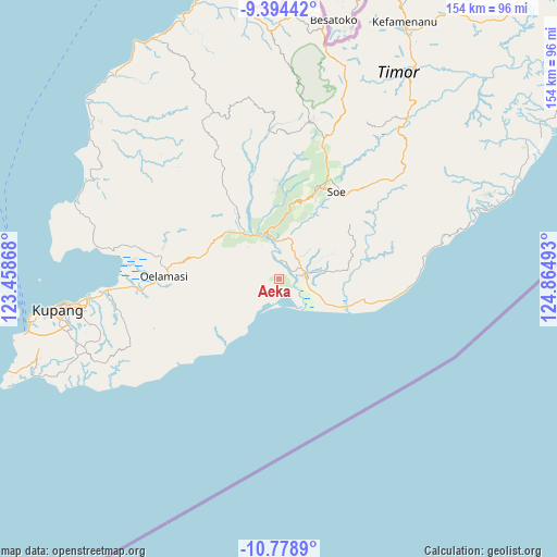
Aeka GPS coordinates[2]
10° 5' 14.64" South, 124° 9' 42.48" East
| Map corner | latitude | longitude |
|---|---|---|
| Upper-left | -9.39442°, | 123.45868° |
| Center: | -10.0874°, | 124.1618° |
| Lower-right: | -10.7789°, | 124.86493° |
| Map W x H: | 153.9×153.9 km | = 95.6×95.6mi |
| max Lat: | 5.88969° ⇑97.2% North |
| Aeka: | -10.0874° |
| min Lat: | ⇓2.8% South -10.934° |
| min Long | Aeka | max Long |
| 95.1345° | 124.1618° | 140.9419° |
| W 94.7%⇐ | ⇒5.3% E |
Elevation
Elevation of Aeka is 279 m = 915 ft, and this is 49.3 m = 162 ft above average elevation for this country.
| Max E: |
3185 m = 10449 ft | 31% |
| Aeka | 279 m 915 ft | |
| Avg. | 229.7 m = 754 ft | |
Min E: |
-1 m = -3 ft | 69% |
See also: Indonesia elevation on elevation.city.
Geographical zone
Aeka is located in South Torrid zone (between Equator and Tropic of Capricorn). Distance of Equator is 1121.6 km =696.9 mi to North.| Distance of | km | miles | from Aeka |
|---|---|---|---|
| Equator | 1121.6 | 696.9 | to North |
| Tropic Capricorn | 1484.3 | 922.3 | to South |
| Antarctic Circle | 6279.6 | 3902 | to South |
| South Pole | 8885.4 | 5521.1 | to South |


Nearby cities:
15 places around Aeka: (largest is in red/bold)
• Bikoen
4.2 km =2.6 mi,  138°
138°
• Luluf
9 km =5.6 mi,  77°
77°
• Muke
7.9 km =4.9 mi,  241°
241°
• Oebai
11.9 km =7.4 mi,  12°
12°
• Oehaunu
4.9 km =3 mi,  313°
313°
• Oekero
14.4 km =8.9 mi, 238°
• Oemofa
5.1 km =3.2 mi,  269°
269°
• Oenuntono
10.1 km =6.3 mi, 266°
• Oetaman
5.1 km =3.2 mi,  23°
23°
• Panite
7.5 km =4.7 mi, 75°
• Polo
7.8 km =4.8 mi,  71°
71°
• Tabu
12.8 km =8 mi,  62°
62°
• Toifeu
7.5 km =4.7 mi,  93°
93°
• Tubunaen
12.3 km =7.6 mi,  348°
348°
• Tubunain
12.7 km =7.9 mi,  337°
337°
Sources, notices
• [Note1] Compared only with cities in Indonesia existing in our database
• [Src1] Map data: © OpenStreetMap contributors (CC-BY-SA)
• [Src2] Other city data from geonames.org with taken over terms of usage.
• [Src3] Geographical zone / Annual Mean Temperature by Robert A. Rohde @ Wikipedia
