Nifunaibesi geodata
Nifunaibesi (East Nusa Tenggara) is a seat of a fourth-order administrative division; located in Indonesia in Asia/Makassar (GMT+8) time zone. In our database, there are 407 cities with bigger population. Compared to other cities in Indonesia, 94.4% of cities are located further ↑North; 96.4% of cities are located further ←West and 76.1% of cities have lower elevation than Nifunaibesi. Note1


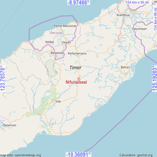
Nifunaibesi GPS coordinates[2]
9° 40' 6.6" South, 124° 29' 20.04" East
| Map corner | latitude | longitude |
|---|---|---|
| Upper-left | -8.97466°, | 123.78578° |
| Center: | -9.6685°, | 124.4889° |
| Lower-right: | -10.36091°, | 125.19203° |
| Map W x H: | 154.1×154.1 km | = 95.8×95.8mi |
| max Lat: | 5.88969° ⇑94.4% North |
| Nifunaibesi: | -9.6685° |
| min Lat: | ⇓5.6% South -10.934° |
| min Long | Nifunaibesi | max Long |
| 95.1345° | 124.4889° | 140.9419° |
| W 96.4%⇐ | ⇒3.6% E |
Elevation
Elevation of Nifunaibesi is 374 m = 1227 ft, and this is 144.3 m = 473 ft above average elevation for this country.
| Max E: |
3185 m = 10449 ft | 23.9% |
| Nifunaibesi | 374 m 1227 ft | |
| Avg. | 229.7 m = 754 ft | |
Min E: |
-1 m = -3 ft | 76.1% |
See also: Indonesia elevation on elevation.city.
Geographical zone
Nifunaibesi is located in South Torrid zone (between Equator and Tropic of Capricorn). Distance of Equator is 1075 km =668 mi to North.| Distance of | km | miles | from Nifunaibesi |
|---|---|---|---|
| Equator | 1075 | 668 | to North |
| Tropic Capricorn | 1530.9 | 951.3 | to South |
| Antarctic Circle | 6326.1 | 3930.9 | to South |
| South Pole | 8932 | 5550.1 | to South |


Nearby cities:
15 places around Nifunaibesi: (largest is in red/bold)
• Biito
7.9 km =4.9 mi,  73°
73°
• Bijeli
8.8 km =5.5 mi,  0°
0°
• Fatumuti
11.2 km =7 mi,  357°
357°
• Kiuola
9.5 km =5.9 mi,  339°
339°
• Kuaeno
11 km =6.8 mi,  113°
113°
• Neosob
10.3 km =6.4 mi,  184°
184°
• Nibaaf
10.1 km =6.3 mi,  24°
24°
• Noemuti
11.2 km =7 mi, 3°
• Nunhala
5.2 km =3.2 mi, 4°
• Oelet
6.5 km =4 mi,  131°
131°
• Oeoh
7.6 km =4.7 mi, 183°
• Pakaebena
10.5 km =6.5 mi, 2°
• Polen
2.3 km =1.4 mi,  204°
204°
• Popnam
6.7 km =4.2 mi,  43°
43°
• Toifae
7.6 km =4.7 mi,  243°
243°
Sources, notices
• [Note1] Compared only with cities in Indonesia existing in our database
• [Src1] Map data: © OpenStreetMap contributors (CC-BY-SA)
• [Src2] Other city data from geonames.org with taken over terms of usage.
• [Src3] Geographical zone / Annual Mean Temperature by Robert A. Rohde @ Wikipedia
