Oelet geodata
Oelet (East Nusa Tenggara) is a seat of a fourth-order administrative division; located in Indonesia in Asia/Makassar (GMT+8) time zone. In our database, there are 407 cities with bigger population. Compared to other cities in Indonesia, 94.8% of cities are located further ↑North; 96.7% of cities are located further ←West and 78.5% of cities have lower elevation than Oelet. Note1


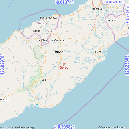
Oelet GPS coordinates[2]
9° 42' 27" South, 124° 31' 58.44" East
| Map corner | latitude | longitude |
|---|---|---|
| Upper-left | -9.01374°, | 123.82978° |
| Center: | -9.7075°, | 124.5329° |
| Lower-right: | -10.39982°, | 125.23603° |
| Map W x H: | 154.1×154.1 km | = 95.8×95.8mi |
| max Lat: | 5.88969° ⇑94.8% North |
| Oelet: | -9.7075° |
| min Lat: | ⇓5.2% South -10.934° |
| min Long | Oelet | max Long |
| 95.1345° | 124.5329° | 140.9419° |
| W 96.7%⇐ | ⇒3.3% E |
Elevation
Elevation of Oelet is 405 m = 1329 ft, and this is 175.3 m = 575 ft above average elevation for this country.
| Max E: |
3185 m = 10449 ft | 21.5% |
| Oelet | 405 m 1329 ft | |
| Avg. | 229.7 m = 754 ft | |
Min E: |
-1 m = -3 ft | 78.5% |
See also: Indonesia elevation on elevation.city.
Geographical zone
Oelet is located in South Torrid zone (between Equator and Tropic of Capricorn). Distance of Equator is 1079.4 km =670.7 mi to North.| Distance of | km | miles | from Oelet |
|---|---|---|---|
| Equator | 1079.4 | 670.7 | to North |
| Tropic Capricorn | 1526.5 | 948.5 | to South |
| Antarctic Circle | 6321.8 | 3928.2 | to South |
| South Pole | 8927.7 | 5547.4 | to South |


Nearby cities:
15 places around Oelet: (largest is in red/bold)
• Biito
7.2 km =4.5 mi,  22°
22°
• Bileon
8.7 km =5.4 mi,  177°
177°
• Kolo
6.8 km =4.2 mi,  126°
126°
• Kuaeno
5.2 km =3.2 mi,  91°
91°
• Neosob
8.1 km =5 mi,  223°
223°
• Nifunaibesi
6.5 km =4 mi,  311°
311°
• Oeekam
6.1 km =3.8 mi, 91°
• Oeoh
6.1 km =3.8 mi,  238°
238°
• Oesapi
8.6 km =5.3 mi,  97°
97°
• Oetua
8.3 km =5.2 mi,  71°
71°
• Pili
8.3 km =5.2 mi,  201°
201°
• Pisan
7.8 km =4.8 mi,  114°
114°
• Polen
6.2 km =3.9 mi,  291°
291°
• Popnam
9.2 km =5.7 mi,  359°
359°
• Sopo
9.8 km =6.1 mi, 220°
Sources, notices
• [Note1] Compared only with cities in Indonesia existing in our database
• [Src1] Map data: © OpenStreetMap contributors (CC-BY-SA)
• [Src2] Other city data from geonames.org with taken over terms of usage.
• [Src3] Geographical zone / Annual Mean Temperature by Robert A. Rohde @ Wikipedia
