Fatufaun geodata
Fatufaun (East Nusa Tenggara) is a seat of a fourth-order administrative division; located in Indonesia in Asia/Makassar (GMT+8) time zone. In our database, there are 407 cities with bigger population. Compared to other cities in Indonesia, 93.4% of cities are located further ↑North; 95.5% of cities are located further ←West and 98.4% of cities have lower elevation than Fatufaun. Note1


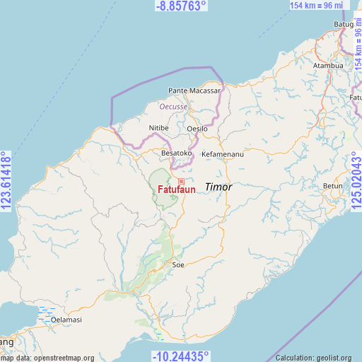
Fatufaun GPS coordinates[2]
9° 33' 6.12" South, 124° 19' 2.28" East
| Map corner | latitude | longitude |
|---|---|---|
| Upper-left | -8.85763°, | 123.61418° |
| Center: | -9.5517°, | 124.3173° |
| Lower-right: | -10.24435°, | 125.02043° |
| Map W x H: | 154.2×154.2 km | = 95.8×95.8mi |
| max Lat: | 5.88969° ⇑93.4% North |
| Fatufaun: | -9.5517° |
| min Lat: | ⇓6.6% South -10.934° |
| min Long | Fatufaun | max Long |
| 95.1345° | 124.3173° | 140.9419° |
| W 95.5%⇐ | ⇒4.5% E |
Elevation
Elevation of Fatufaun is 1093 m = 3586 ft, and this is 863.3 m = 2832 ft above average elevation for this country.
| Max E: |
3185 m = 10449 ft | 1.6% |
| Fatufaun | 1093 m 3586 ft | |
| Avg. | 229.7 m = 754 ft | |
Min E: |
-1 m = -3 ft | 98.4% |
See also: Indonesia elevation on elevation.city.
Geographical zone
Fatufaun is located in South Torrid zone (between Equator and Tropic of Capricorn). Distance of Equator is 1062 km =659.9 mi to North.| Distance of | km | miles | from Fatufaun |
|---|---|---|---|
| Equator | 1062 | 659.9 | to North |
| Tropic Capricorn | 1543.9 | 959.3 | to South |
| Antarctic Circle | 6339.1 | 3938.9 | to South |
| South Pole | 8945 | 5558.2 | to South |


Nearby cities:
15 places around Fatufaun: (largest is in red/bold)
• Bestamuti
9.6 km =6 mi,  190°
190°
• Binab
4.7 km =2.9 mi,  220°
220°
• Eban
0.8 km =0.5 mi,  109°
109°
• Muesanaik
7.5 km =4.7 mi,  49°
49°
• Nilulat
5.8 km =3.6 mi,  13°
13°
• Noeltoko
4.9 km =3 mi,  70°
70°
• Nunpo
8.5 km =5.3 mi,  29°
29°
• Oebaki
7.4 km =4.6 mi,  92°
92°
• Oenaek
2.4 km =1.5 mi,  270°
270°
• Oenaik
4.7 km =2.9 mi,  115°
115°
• Oenam
5.1 km =3.2 mi,  161°
161°
• Oesena
2.9 km =1.8 mi,  262°
262°
• Saenam
1.9 km =1.2 mi,  308°
308°
• Seoam
1.5 km =0.9 mi,  104°
104°
• Suanae
2.3 km =1.4 mi,  128°
128°
Sources, notices
• [Note1] Compared only with cities in Indonesia existing in our database
• [Src1] Map data: © OpenStreetMap contributors (CC-BY-SA)
• [Src2] Other city data from geonames.org with taken over terms of usage.
• [Src3] Geographical zone / Annual Mean Temperature by Robert A. Rohde @ Wikipedia
