Oesena geodata
Oesena (East Nusa Tenggara) is a seat of a fourth-order administrative division; located in Indonesia in Asia/Makassar (GMT+8) time zone. In our database, there are 407 cities with bigger population. Compared to other cities in Indonesia, 93.4% of cities are located further ↑North; 95.3% of cities are located further ←West and 98.6% of cities have lower elevation than Oesena. Note1


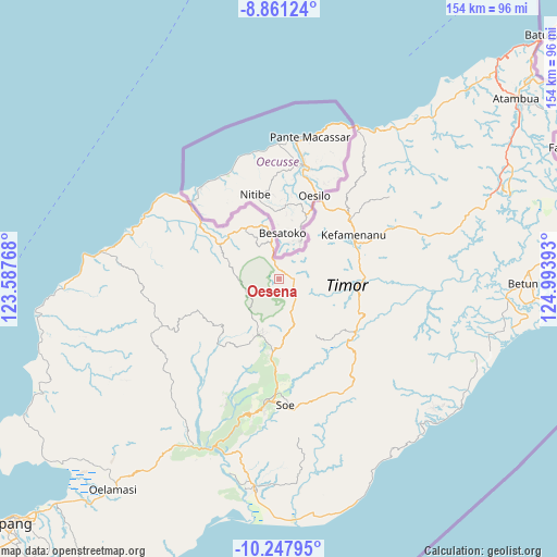
Oesena GPS coordinates[2]
9° 33' 19.08" South, 124° 17' 26.88" East
| Map corner | latitude | longitude |
|---|---|---|
| Upper-left | -8.86124°, | 123.58768° |
| Center: | -9.5553°, | 124.2908° |
| Lower-right: | -10.24795°, | 124.99393° |
| Map W x H: | 154.2×154.2 km | = 95.8×95.8mi |
| max Lat: | 5.88969° ⇑93.4% North |
| Oesena: | -9.5553° |
| min Lat: | ⇓6.6% South -10.934° |
| min Long | Oesena | max Long |
| 95.1345° | 124.2908° | 140.9419° |
| W 95.3%⇐ | ⇒4.7% E |
Elevation
Elevation of Oesena is 1150 m = 3773 ft, and this is 920.3 m = 3019 ft above average elevation for this country.
| Max E: |
3185 m = 10449 ft | 1.4% |
| Oesena | 1150 m 3773 ft | |
| Avg. | 229.7 m = 754 ft | |
Min E: |
-1 m = -3 ft | 98.6% |
See also: Indonesia elevation on elevation.city.
Geographical zone
Oesena is located in South Torrid zone (between Equator and Tropic of Capricorn). Distance of Equator is 1062.4 km =660.1 mi to North.| Distance of | km | miles | from Oesena |
|---|---|---|---|
| Equator | 1062.4 | 660.1 | to North |
| Tropic Capricorn | 1543.5 | 959.1 | to South |
| Antarctic Circle | 6338.7 | 3938.7 | to South |
| South Pole | 8944.6 | 5557.9 | to South |


Nearby cities:
15 places around Oesena: (largest is in red/bold)
• Bestamuti
9.2 km =5.7 mi,  172°
172°
• Binab
3.1 km =1.9 mi,  182°
182°
• Eban
3.7 km =2.3 mi,  87°
87°
• Fatufaun
2.9 km =1.8 mi,  82°
82°
• Muesanaik
10.1 km =6.3 mi,  58°
58°
• Nenas
9.9 km =6.2 mi,  252°
252°
• Nilulat
7.4 km =4.6 mi,  34°
34°
• Noeltoko
7.8 km =4.8 mi, 75°
• Oebaki
10.3 km =6.4 mi, 89°
• Oenaek
0.6 km =0.4 mi,  46°
46°
• Oenaik
7.3 km =4.5 mi,  103°
103°
• Oenam
6.3 km =3.9 mi,  134°
134°
• Saenam
2.1 km =1.3 mi,  40°
40°
• Seoam
4.4 km =2.7 mi, 89°
• Suanae
4.8 km =3 mi, 102°
Sources, notices
• [Note1] Compared only with cities in Indonesia existing in our database
• [Src1] Map data: © OpenStreetMap contributors (CC-BY-SA)
• [Src2] Other city data from geonames.org with taken over terms of usage.
• [Src3] Geographical zone / Annual Mean Temperature by Robert A. Rohde @ Wikipedia
