Fuskou geodata
Fuskou (East Nusa Tenggara) is a seat of a fourth-order administrative division; located in Indonesia in Asia/Makassar (GMT+8) time zone. In our database, there are 407 cities with bigger population. Compared to other cities in Indonesia, 98.2% of cities are located further ↑North; 94.4% of cities are located further ←West and 60.6% of cities have higher elevation than Fuskou. Note1


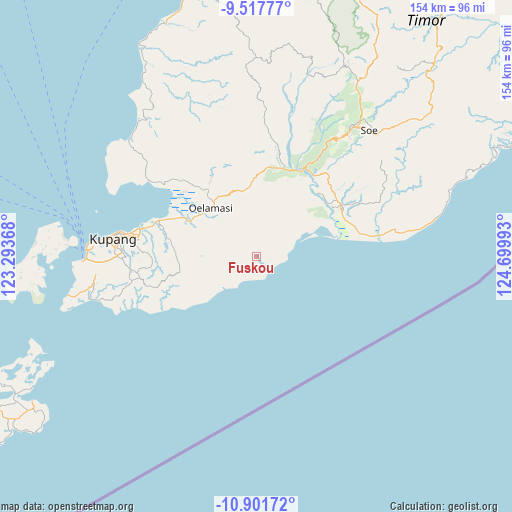
Fuskou GPS coordinates[2]
10° 12' 37.8" South, 123° 59' 48.48" East
| Map corner | latitude | longitude |
|---|---|---|
| Upper-left | -9.51777°, | 123.29368° |
| Center: | -10.2105°, | 123.9968° |
| Lower-right: | -10.90172°, | 124.69993° |
| Map W x H: | 153.9×153.9 km | = 95.6×95.6mi |
| max Lat: | 5.88969° ⇑98.2% North |
| Fuskou: | -10.2105° |
| min Lat: | ⇓1.8% South -10.934° |
| min Long | Fuskou | max Long |
| 95.1345° | 123.9968° | 140.9419° |
| W 94.4%⇐ | ⇒5.6% E |
Elevation
Elevation of Fuskou is 57 m = 187 ft, and this is 172.7 m = 567 ft below average elevation for this country.
| Max E: |
3185 m = 10449 ft | 60.6% |
| Avg. | 229.7 m = 754 ft | |
| Fuskou | 57 m = 187 ft | |
Min E: |
-1 m = -3 ft | 39.4% |
See also: Indonesia elevation on elevation.city.
Geographical zone
Fuskou is located in South Torrid zone (between Equator and Tropic of Capricorn). Distance of Equator is 1135.3 km =705.4 mi to North.| Distance of | km | miles | from Fuskou |
|---|---|---|---|
| Equator | 1135.3 | 705.4 | to North |
| Tropic Capricorn | 1470.6 | 913.8 | to South |
| Antarctic Circle | 6265.9 | 3893.4 | to South |
| South Pole | 8871.8 | 5512.7 | to South |


Nearby cities:
15 places around Fuskou: (largest is in red/bold)
• Boitimu
1.9 km =1.2 mi,  162°
162°
• Buka
6.8 km =4.2 mi,  270°
270°
• Buraen
17.4 km =10.8 mi,  241°
241°
• Fatukanutu
11.5 km =7.1 mi,  293°
293°
• Hauhena
8.9 km =5.5 mi,  254°
254°
• Kairane
8.4 km =5.2 mi,  316°
316°
• Kiukasen
13.1 km =8.1 mi,  310°
310°
• Kuanheum
14.1 km =8.8 mi, 287°
• Muke
14.9 km =9.3 mi,  48°
48°
• Oekero
8.4 km =5.2 mi,  43°
43°
• Oenuntono
15.3 km =9.5 mi,  31°
31°
• Ponain
15.8 km =9.8 mi, 271°
• Tanbira
12.2 km =7.6 mi, 271°
• Tuamese
13.9 km =8.6 mi, 253°
• Tunmunih
18.2 km =11.3 mi,  355°
355°
Sources, notices
• [Note1] Compared only with cities in Indonesia existing in our database
• [Src1] Map data: © OpenStreetMap contributors (CC-BY-SA)
• [Src2] Other city data from geonames.org with taken over terms of usage.
• [Src3] Geographical zone / Annual Mean Temperature by Robert A. Rohde @ Wikipedia
