Oekero geodata
Oekero (East Nusa Tenggara) is a seat of a fourth-order administrative division; located in Indonesia in Asia/Makassar (GMT+8) time zone. In our database, there are 407 cities with bigger population. Compared to other cities in Indonesia, 97.6% of cities are located further ↑North; 94.5% of cities are located further ←West and 65.5% of cities have lower elevation than Oekero. Note1


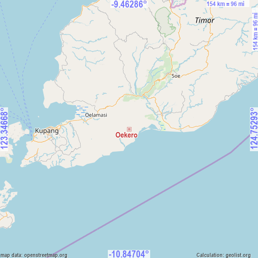
Oekero GPS coordinates[2]
10° 9' 20.52" South, 124° 2' 59.28" East
| Map corner | latitude | longitude |
|---|---|---|
| Upper-left | -9.46286°, | 123.34668° |
| Center: | -10.1557°, | 124.0498° |
| Lower-right: | -10.84704°, | 124.75293° |
| Map W x H: | 153.9×153.9 km | = 95.6×95.6mi |
| max Lat: | 5.88969° ⇑97.6% North |
| Oekero: | -10.1557° |
| min Lat: | ⇓2.4% South -10.934° |
| min Long | Oekero | max Long |
| 95.1345° | 124.0498° | 140.9419° |
| W 94.5%⇐ | ⇒5.5% E |
Elevation
Elevation of Oekero is 229 m = 751 ft, and this is 0.69999999999999 m = 2 ft below average elevation for this country.
| Max E: |
3185 m = 10449 ft | 34.5% |
| Avg. | 229.7 m = 754 ft | |
| Oekero | 229 m = 751 ft | |
Min E: |
-1 m = -3 ft | 65.5% |
See also: Indonesia elevation on elevation.city.
Geographical zone
Oekero is located in South Torrid zone (between Equator and Tropic of Capricorn). Distance of Equator is 1129.2 km =701.7 mi to North.| Distance of | km | miles | from Oekero |
|---|---|---|---|
| Equator | 1129.2 | 701.7 | to North |
| Tropic Capricorn | 1476.7 | 917.6 | to South |
| Antarctic Circle | 6272 | 3897.2 | to South |
| South Pole | 8877.9 | 5516.5 | to South |


Nearby cities:
15 places around Oekero: (largest is in red/bold)
• Aeka
14.4 km =8.9 mi,  58°
58°
• Bikoen
15.7 km =9.8 mi,  73°
73°
• Boitimu
9.5 km =5.9 mi,  213°
213°
• Buka
14 km =8.7 mi,  244°
244°
• Fatukanutu
16.4 km =10.2 mi,  264°
264°
• Fuskou
8.4 km =5.2 mi,  223°
223°
• Hauhena
16.7 km =10.4 mi, 239°
• Kairane
11.6 km =7.2 mi,  270°
270°
• Kiukasen
15.9 km =9.9 mi,  279°
279°
• Muke
6.5 km =4 mi,  54°
54°
• Naikolan
18.3 km =11.4 mi,  309°
309°
• Oehaunu
14 km =8.7 mi,  38°
38°
• Oemofa
10.4 km =6.5 mi, 43°
• Oenuntono
7.4 km =4.6 mi,  16°
16°
• Tunmunih
14.1 km =8.8 mi,  328°
328°
Sources, notices
• [Note1] Compared only with cities in Indonesia existing in our database
• [Src1] Map data: © OpenStreetMap contributors (CC-BY-SA)
• [Src2] Other city data from geonames.org with taken over terms of usage.
• [Src3] Geographical zone / Annual Mean Temperature by Robert A. Rohde @ Wikipedia
