Oebubun geodata
Oebubun (East Nusa Tenggara) is a seat of a fourth-order administrative division; located in Indonesia in Asia/Makassar (GMT+8) time zone. In our database, there are 407 cities with bigger population. Compared to other cities in Indonesia, 95.9% of cities are located further ↑North; 97% of cities are located further ←West and 97.2% of cities have lower elevation than Oebubun. Note1


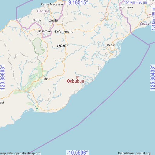
Oebubun GPS coordinates[2]
9° 51' 30.96" South, 124° 36' 4.32" East
| Map corner | latitude | longitude |
|---|---|---|
| Upper-left | -9.16515°, | 123.89808° |
| Center: | -9.8586°, | 124.6012° |
| Lower-right: | -10.5506°, | 125.30433° |
| Map W x H: | 154×154.1 km | = 95.7×95.8mi |
| max Lat: | 5.88969° ⇑95.9% North |
| Oebubun: | -9.8586° |
| min Lat: | ⇓4.1% South -10.934° |
| min Long | Oebubun | max Long |
| 95.1345° | 124.6012° | 140.9419° |
| W 97%⇐ | ⇒3% E |
Elevation
Elevation of Oebubun is 968 m = 3176 ft, and this is 738.3 m = 2422 ft above average elevation for this country.
| Max E: |
3185 m = 10449 ft | 2.8% |
| Oebubun | 968 m 3176 ft | |
| Avg. | 229.7 m = 754 ft | |
Min E: |
-1 m = -3 ft | 97.2% |
See also: Indonesia elevation on elevation.city.
Geographical zone
Oebubun is located in South Torrid zone (between Equator and Tropic of Capricorn). Distance of Equator is 1096.2 km =681.1 mi to North.| Distance of | km | miles | from Oebubun |
|---|---|---|---|
| Equator | 1096.2 | 681.1 | to North |
| Tropic Capricorn | 1509.7 | 938.1 | to South |
| Antarctic Circle | 6305 | 3917.7 | to South |
| South Pole | 8910.9 | 5537 | to South |


Nearby cities:
15 places around Oebubun: (largest is in red/bold)
• Anin
3 km =1.9 mi,  306°
306°
• Ayofanu
2.2 km =1.4 mi,  211°
211°
• Fatuhilik
6.1 km =3.8 mi,  2°
2°
• Fatuulan
5.6 km =3.5 mi,  165°
165°
• Haumeni
6.7 km =4.2 mi,  116°
116°
• Kie
6 km =3.7 mi,  284°
284°
• Kualeu
5.6 km =3.5 mi,  93°
93°
• Linakelopu
5.8 km =3.6 mi, 1°
• Nunleu
3.5 km =2.2 mi,  132°
132°
• Oenpeotnai
3.4 km =2.1 mi, 281°
• Oinlasi
3.1 km =1.9 mi,  288°
288°
• Poto
5.8 km =3.6 mi, 207°
• Sbo’o
6.3 km =3.9 mi,  69°
69°
• Sunu
6.2 km =3.9 mi,  45°
45°
• Tene
3.8 km =2.4 mi,  57°
57°
Sources, notices
• [Note1] Compared only with cities in Indonesia existing in our database
• [Src1] Map data: © OpenStreetMap contributors (CC-BY-SA)
• [Src2] Other city data from geonames.org with taken over terms of usage.
• [Src3] Geographical zone / Annual Mean Temperature by Robert A. Rohde @ Wikipedia
