Tunis geodata
Tunis (East Nusa Tenggara) is a seat of a fourth-order administrative division; located in Indonesia in Asia/Makassar (GMT+8) time zone. In our database, there are 407 cities with bigger population. Compared to other cities in Indonesia, 95.3% of cities are located further ↑North; 97.1% of cities are located further ←West and 94.7% of cities have lower elevation than Tunis. Note1


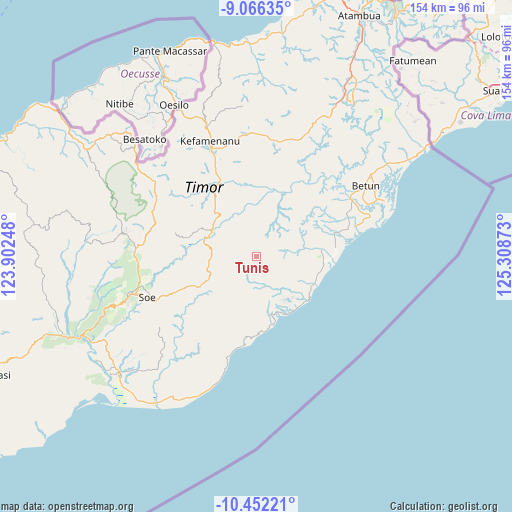
Tunis GPS coordinates[2]
9° 45' 36" South, 124° 36' 20.16" East
| Map corner | latitude | longitude |
|---|---|---|
| Upper-left | -9.06635°, | 123.90248° |
| Center: | -9.76°, | 124.6056° |
| Lower-right: | -10.45221°, | 125.30873° |
| Map W x H: | 154.1×154.1 km | = 95.8×95.8mi |
| max Lat: | 5.88969° ⇑95.3% North |
| Tunis: | -9.76° |
| min Lat: | ⇓4.7% South -10.934° |
| min Long | Tunis | max Long |
| 95.1345° | 124.6056° | 140.9419° |
| W 97.1%⇐ | ⇒2.9% E |
Elevation
Elevation of Tunis is 800 m = 2625 ft, and this is 570.3 m = 1871 ft above average elevation for this country.
| Max E: |
3185 m = 10449 ft | 5.3% |
| Tunis | 800 m 2625 ft | |
| Avg. | 229.7 m = 754 ft | |
Min E: |
-1 m = -3 ft | 94.7% |
See also: Indonesia elevation on elevation.city.
Geographical zone
Tunis is located in South Torrid zone (between Equator and Tropic of Capricorn). Distance of Equator is 1085.2 km =674.3 mi to North.| Distance of | km | miles | from Tunis |
|---|---|---|---|
| Equator | 1085.2 | 674.3 | to North |
| Tropic Capricorn | 1520.7 | 944.9 | to South |
| Antarctic Circle | 6316 | 3924.6 | to South |
| South Pole | 8921.9 | 5543.8 | to South |


Nearby cities:
15 places around Tunis: (largest is in red/bold)
• Bileon
8.1 km =5 mi,  249°
249°
• Fatuhilik
4.9 km =3 mi,  181°
181°
• Kolo
3.1 km =1.9 mi,  305°
305°
• Kuaeno
6.4 km =4 mi,  334°
334°
• Linakelopu
5.2 km =3.2 mi, 183°
• Mnelabano
8.8 km =5.5 mi,  52°
52°
• Noebana
5.9 km =3.7 mi,  103°
103°
• Oeekam
6 km =3.7 mi,  341°
341°
• Oefenu
7.5 km =4.7 mi,  87°
87°
• Oeleon
4.7 km =2.9 mi,  222°
222°
• Oesapi
4.7 km =2.9 mi,  6°
6°
• Oetua
8.4 km =5.2 mi,  359°
359°
• Pisan
2.8 km =1.7 mi, 341°
• Sunu
7.7 km =4.8 mi,  149°
149°
• Tuateta
6.4 km =4 mi, 48°
Sources, notices
• [Note1] Compared only with cities in Indonesia existing in our database
• [Src1] Map data: © OpenStreetMap contributors (CC-BY-SA)
• [Src2] Other city data from geonames.org with taken over terms of usage.
• [Src3] Geographical zone / Annual Mean Temperature by Robert A. Rohde @ Wikipedia
