Fatuhilik geodata
Fatuhilik (East Nusa Tenggara) is a seat of a fourth-order administrative division; located in Indonesia in Asia/Makassar (GMT+8) time zone. In our database, there are 407 cities with bigger population. Compared to other cities in Indonesia, 95.5% of cities are located further ↑North; 97.1% of cities are located further ←West and 93.4% of cities have lower elevation than Fatuhilik. Note1


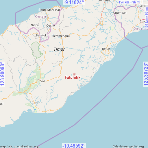
Fatuhilik GPS coordinates[2]
9° 48' 13.68" South, 124° 36' 14.76" East
| Map corner | latitude | longitude |
|---|---|---|
| Upper-left | -9.11024°, | 123.90098° |
| Center: | -9.8038°, | 124.6041° |
| Lower-right: | -10.49592°, | 125.30723° |
| Map W x H: | 154.1×154.1 km | = 95.8×95.8mi |
| max Lat: | 5.88969° ⇑95.5% North |
| Fatuhilik: | -9.8038° |
| min Lat: | ⇓4.5% South -10.934° |
| min Long | Fatuhilik | max Long |
| 95.1345° | 124.6041° | 140.9419° |
| W 97.1%⇐ | ⇒2.9% E |
Elevation
Elevation of Fatuhilik is 746 m = 2448 ft, and this is 516.3 m = 1694 ft above average elevation for this country.
| Max E: |
3185 m = 10449 ft | 6.6% |
| Fatuhilik | 746 m 2448 ft | |
| Avg. | 229.7 m = 754 ft | |
Min E: |
-1 m = -3 ft | 93.4% |
See also: Indonesia elevation on elevation.city.
Geographical zone
Fatuhilik is located in South Torrid zone (between Equator and Tropic of Capricorn). Distance of Equator is 1090.1 km =677.4 mi to North.| Distance of | km | miles | from Fatuhilik |
|---|---|---|---|
| Equator | 1090.1 | 677.4 | to North |
| Tropic Capricorn | 1515.8 | 941.9 | to South |
| Antarctic Circle | 6311.1 | 3921.5 | to South |
| South Pole | 8917 | 5540.8 | to South |


Nearby cities:
15 places around Fatuhilik: (largest is in red/bold)
• Anin
5.1 km =3.2 mi,  212°
212°
• Bileon
7.7 km =4.8 mi,  285°
285°
• Kie
7.6 km =4.7 mi,  233°
233°
• Kolo
7.1 km =4.4 mi,  340°
340°
• Linakelopu
0.3 km =0.2 mi,  202°
202°
• Noebana
6.8 km =4.2 mi,  59°
59°
• Oebubun
6.1 km =3.8 mi,  182°
182°
• Oeleon
3.3 km =2.1 mi, 294°
• Oenpeotnai
6.5 km =4 mi, 214°
• Oinlasi
6.1 km =3.8 mi, 212°
• Pisan
7.5 km =4.7 mi,  354°
354°
• Sbo’o
6.8 km =4.2 mi,  125°
125°
• Sunu
4.4 km =2.7 mi,  113°
113°
• Tene
5 km =3.1 mi,  144°
144°
• Tunis
4.9 km =3 mi,  1°
1°
Sources, notices
• [Note1] Compared only with cities in Indonesia existing in our database
• [Src1] Map data: © OpenStreetMap contributors (CC-BY-SA)
• [Src2] Other city data from geonames.org with taken over terms of usage.
• [Src3] Geographical zone / Annual Mean Temperature by Robert A. Rohde @ Wikipedia
