Watugolok geodata
Watugolok (East Nusa Tenggara) is a seat of a third-order administrative division; located in Indonesia in Asia/Makassar (GMT+8) time zone. In our database, there are 407 cities with bigger population. Compared to other cities in Indonesia, 81.4% of cities are located further ↑North; 92.2% of cities are located further ←West and 88.5% of cities have lower elevation than Watugolok. Note1


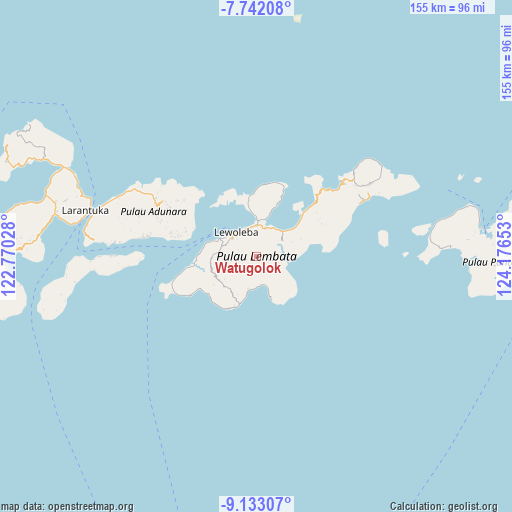
Watugolok GPS coordinates[2]
8° 26' 17.52" South, 123° 28' 24.24" East
| Map corner | latitude | longitude |
|---|---|---|
| Upper-left | -7.74208°, | 122.77028° |
| Center: | -8.4382°, | 123.4734° |
| Lower-right: | -9.13307°, | 124.17653° |
| Map W x H: | 154.7×154.7 km | = 96.1×96.1mi |
| max Lat: | 5.88969° ⇑81.4% North |
| Watugolok: | -8.4382° |
| min Lat: | ⇓18.6% South -10.934° |
| min Long | Watugolok | max Long |
| 95.1345° | 123.4734° | 140.9419° |
| W 92.2%⇐ | ⇒7.8% E |
Elevation
Elevation of Watugolok is 596 m = 1955 ft, and this is 366.3 m = 1202 ft above average elevation for this country.
| Max E: |
3185 m = 10449 ft | 11.5% |
| Watugolok | 596 m 1955 ft | |
| Avg. | 229.7 m = 754 ft | |
Min E: |
-1 m = -3 ft | 88.5% |
See also: Indonesia elevation on elevation.city.
Geographical zone
Watugolok is located in South Torrid zone (between Equator and Tropic of Capricorn). Distance of Equator is 938.2 km =583 mi to North.| Distance of | km | miles | from Watugolok |
|---|---|---|---|
| Equator | 938.2 | 583 | to North |
| Tropic Capricorn | 1667.7 | 1036.3 | to South |
| Antarctic Circle | 6462.9 | 4015.9 | to South |
| South Pole | 9068.8 | 5635.1 | to South |


Nearby cities:
15 places around Watugolok: (largest is in red/bold)
• Bakan
3.1 km =1.9 mi,  185°
185°
• Kalikasa
0.8 km =0.5 mi,  308°
308°
• Karangora
4 km =2.5 mi,  105°
105°
• Kolirerek
0.8 km =0.5 mi,  196°
196°
• Labala
8.7 km =5.4 mi,  167°
167°
• Lamatuka
8.6 km =5.3 mi,  17°
17°
• Lewokukung
3.1 km =1.9 mi,  251°
251°
• Lewoleba
9.5 km =5.9 mi,  320°
320°
• Lewuka
7.2 km =4.5 mi, 202°
• Merdeka
9.9 km =6.2 mi,  36°
36°
• Mulankera
8.8 km =5.5 mi, 171°
• Paobokol
9.2 km =5.7 mi,  234°
234°
• Paulolong
6.4 km =4 mi,  152°
152°
• Tanakereket
9.1 km =5.7 mi, 19°
• Waiwejak
8.6 km =5.3 mi,  141°
141°
Sources, notices
• [Note1] Compared only with cities in Indonesia existing in our database
• [Src1] Map data: © OpenStreetMap contributors (CC-BY-SA)
• [Src2] Other city data from geonames.org with taken over terms of usage.
• [Src3] Geographical zone / Annual Mean Temperature by Robert A. Rohde @ Wikipedia
