Kolirerek geodata
Kolirerek (East Nusa Tenggara) is a seat of a fourth-order administrative division; located in Indonesia in Asia/Makassar (GMT+8) time zone. In our database, there are 407 cities with bigger population. Compared to other cities in Indonesia, 81.6% of cities are located further ↑North; 92.2% of cities are located further ←West and 92.8% of cities have lower elevation than Kolirerek. Note1


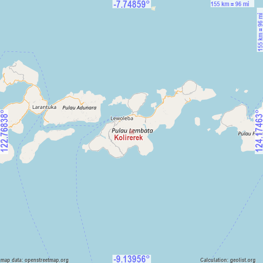
Kolirerek GPS coordinates[2]
8° 26' 40.92" South, 123° 28' 17.4" East
| Map corner | latitude | longitude |
|---|---|---|
| Upper-left | -7.74859°, | 122.76838° |
| Center: | -8.4447°, | 123.4715° |
| Lower-right: | -9.13956°, | 124.17463° |
| Map W x H: | 154.7×154.7 km | = 96.1×96.1mi |
| max Lat: | 5.88969° ⇑81.6% North |
| Kolirerek: | -8.4447° |
| min Lat: | ⇓18.4% South -10.934° |
| min Long | Kolirerek | max Long |
| 95.1345° | 123.4715° | 140.9419° |
| W 92.2%⇐ | ⇒7.8% E |
Elevation
Elevation of Kolirerek is 729 m = 2392 ft, and this is 499.3 m = 1638 ft above average elevation for this country.
| Max E: |
3185 m = 10449 ft | 7.2% |
| Kolirerek | 729 m 2392 ft | |
| Avg. | 229.7 m = 754 ft | |
Min E: |
-1 m = -3 ft | 92.8% |
See also: Indonesia elevation on elevation.city.
Geographical zone
Kolirerek is located in South Torrid zone (between Equator and Tropic of Capricorn). Distance of Equator is 939 km =583.5 mi to North.| Distance of | km | miles | from Kolirerek |
|---|---|---|---|
| Equator | 939 | 583.5 | to North |
| Tropic Capricorn | 1667 | 1035.8 | to South |
| Antarctic Circle | 6462.2 | 4015.4 | to South |
| South Pole | 9068.1 | 5634.7 | to South |


Nearby cities:
15 places around Kolirerek: (largest is in red/bold)
• Atawolo
9.4 km =5.8 mi,  143°
143°
• Bakan
2.4 km =1.5 mi,  181°
181°
• Kalikasa
1.3 km =0.8 mi,  341°
341°
• Karangora
4.1 km =2.5 mi,  94°
94°
• Labala
8.1 km =5 mi,  164°
164°
• Lamatuka
9.4 km =5.8 mi,  17°
17°
• Lewokukung
2.7 km =1.7 mi,  264°
264°
• Lewuka
6.5 km =4 mi,  203°
203°
• Luki
9.8 km =6.1 mi,  191°
191°
• Mulankera
8.1 km =5 mi,  169°
169°
• Paobokol
8.6 km =5.3 mi,  237°
237°
• Paulolong
5.8 km =3.6 mi,  147°
147°
• Tanakereket
9.9 km =6.2 mi, 19°
• Waiwejak
8.2 km =5.1 mi, 136°
• Watugolok
0.8 km =0.5 mi, 16°
Sources, notices
• [Note1] Compared only with cities in Indonesia existing in our database
• [Src1] Map data: © OpenStreetMap contributors (CC-BY-SA)
• [Src2] Other city data from geonames.org with taken over terms of usage.
• [Src3] Geographical zone / Annual Mean Temperature by Robert A. Rohde @ Wikipedia
