Nurabelen geodata
Nurabelen (East Nusa Tenggara) is a seat of a fourth-order administrative division; located in Indonesia in Asia/Makassar (GMT+8) time zone. In our database, there are 407 cities with bigger population. Compared to other cities in Indonesia, 84.1% of cities are located further ↑North; 89.4% of cities are located further ←West and 78.1% of cities have higher elevation than Nurabelen. Note1


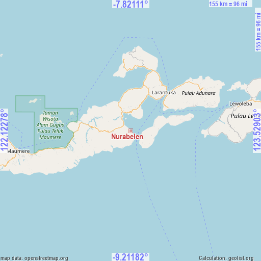
Nurabelen GPS coordinates[2]
8° 31' 1.56" South, 122° 49' 33.24" East
| Map corner | latitude | longitude |
|---|---|---|
| Upper-left | -7.82111°, | 122.12278° |
| Center: | -8.5171°, | 122.8259° |
| Lower-right: | -9.21182°, | 123.52903° |
| Map W x H: | 154.6×154.6 km | = 96.1×96.1mi |
| max Lat: | 5.88969° ⇑84.1% North |
| Nurabelen: | -8.5171° |
| min Lat: | ⇓15.9% South -10.934° |
| min Long | Nurabelen | max Long |
| 95.1345° | 122.8259° | 140.9419° |
| W 89.4%⇐ | ⇒10.6% E |
Elevation
Elevation of Nurabelen is 21 m = 69 ft, and this is 208.7 m = 685 ft below average elevation for this country.
| Max E: |
3185 m = 10449 ft | 78.1% |
| Avg. | 229.7 m = 754 ft | |
| Nurabelen | 21 m = 69 ft | |
Min E: |
-1 m = -3 ft | 21.9% |
See also: Indonesia elevation on elevation.city.
Geographical zone
Nurabelen is located in South Torrid zone (between Equator and Tropic of Capricorn). Distance of Equator is 947 km =588.4 mi to North.| Distance of | km | miles | from Nurabelen |
|---|---|---|---|
| Equator | 947 | 588.4 | to North |
| Tropic Capricorn | 1658.9 | 1030.8 | to South |
| Antarctic Circle | 6454.2 | 4010.5 | to South |
| South Pole | 9060 | 5629.6 | to South |


Nearby cities:
15 places around Nurabelen: (largest is in red/bold)
• Duang
11.7 km =7.3 mi,  247°
247°
• Eputobi
12 km =7.5 mi,  3°
3°
• Kanada
11.6 km =7.2 mi,  326°
326°
• Konga
9.2 km =5.7 mi,  323°
323°
• Lamika
11.3 km =7 mi,  8°
8°
• Lewohokeng
10.4 km =6.5 mi,  136°
136°
• Lewolaga
11 km =6.8 mi,  350°
350°
• Lewotobi
6.6 km =4.1 mi,  170°
170°
• Nobo
5.3 km =3.3 mi,  311°
311°
• Riangbaring
11.3 km =7 mi,  206°
206°
• Riangkaha
3.7 km =2.3 mi,  152°
152°
• Ritaebang
6.5 km =4 mi,  103°
103°
• Ritaebang Satu
6.6 km =4.1 mi, 99°
• Sukutukang
12.4 km =7.7 mi,  277°
277°
• Tanahedang
9.4 km =5.8 mi,  115°
115°
Sources, notices
• [Note1] Compared only with cities in Indonesia existing in our database
• [Src1] Map data: © OpenStreetMap contributors (CC-BY-SA)
• [Src2] Other city data from geonames.org with taken over terms of usage.
• [Src3] Geographical zone / Annual Mean Temperature by Robert A. Rohde @ Wikipedia
