Pugeran Maguwoharjo geodata
Pugeran Maguwoharjo (Yogyakarta) is a populated place; located in Indonesia in Asia/Jakarta (GMT+7) time zone. With population of 600 people, there are 405 cities with bigger population in this country. Compared to other cities in Indonesia, 60.6% of cities are located further ↑North; 65.4% of cities are located further →East and 58.3% of cities have lower elevation than Pugeran Maguwoharjo. Note1


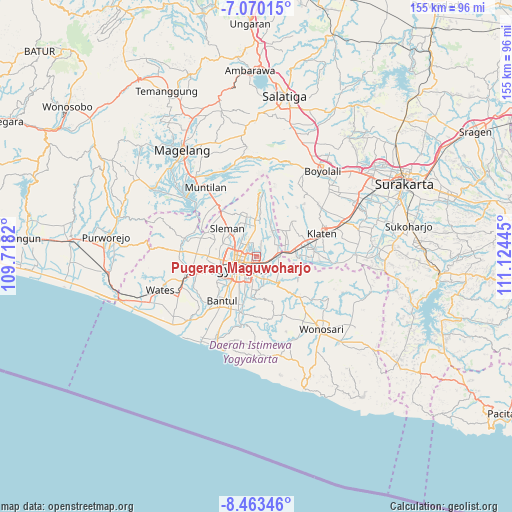
Pugeran Maguwoharjo GPS coordinates[2]
7° 46' 2.568" South, 110° 25' 16.752" East
| Map corner | latitude | longitude |
|---|---|---|
| Upper-left | -7.07015°, | 109.7182° |
| Center: | -7.76738°, | 110.42132° |
| Lower-right: | -8.46346°, | 111.12445° |
| Map W x H: | 154.9×154.9 km | = 96.3×96.3mi |
| max Lat: | 5.88969° ⇑60.6% North |
| Pugeran Maguwoharjo: | -7.76738° |
| min Lat: | ⇓39.4% South -10.934° |
| min Long | Pugeran Maguwoh | max Long |
| 95.1345° | 110.42132° | 140.9419° |
| W 34.6%⇐ | ⇒65.4% E |
Elevation
Elevation of Pugeran Maguwoharjo is 148 m = 486 ft, and this is 81.7 m = 268 ft below average elevation for this country.
| Max E: |
3185 m = 10449 ft | 41.7% |
| Avg. | 229.7 m = 754 ft | |
| Pugeran Maguwoharjo | 148 m = 486 ft | |
Min E: |
-1 m = -3 ft | 58.3% |
See also: Indonesia elevation on elevation.city.
Geographical zone
Pugeran Maguwoharjo is located in South Torrid zone (between Equator and Tropic of Capricorn). Distance of Equator is 863.7 km =536.7 mi to North.| Distance of | km | miles | from Pugeran Maguwoharjo |
|---|---|---|---|
| Equator | 863.7 | 536.7 | to North |
| Tropic Capricorn | 1742.3 | 1082.6 | to South |
| Antarctic Circle | 6537.5 | 4062.2 | to South |
| South Pole | 9143.4 | 5681.4 | to South |


Nearby cities:
15 places around Pugeran Maguwoharjo: (largest is in red/bold)
• Bantul
16.8 km =10.4 mi,  217°
217°
• Candi Prambanan
8.3 km =5.2 mi,  76°
76°
• Depok
1.3 km =0.8 mi,  64°
64°
• Gamping Lor
10.9 km =6.8 mi,  253°
253°
• Godean
14 km =8.7 mi,  268°
268°
• Jogonalan
14.5 km =9 mi, 60°
• Kasihan
12.1 km =7.5 mi,  236°
236°
• Kebonarun
17.3 km =10.7 mi, 64°
• Klaten
21.5 km =13.4 mi,  71°
71°
• Melati
7.1 km =4.4 mi,  302°
302°
• Pandak
21.5 km =13.4 mi, 220°
• Sewon
13.9 km =8.6 mi,  209°
209°
• Sleman
9.3 km =5.8 mi,  308°
308°
• Wedi
17.6 km =10.9 mi, 81°
• Yogyakarta
7.3 km =4.5 mi, 238°
Sources, notices
• [Note1] Compared only with cities in Indonesia existing in our database
• [Src1] Map data: © OpenStreetMap contributors (CC-BY-SA)
• [Src2] Other city data from geonames.org with taken over terms of usage.
• [Src3] Geographical zone / Annual Mean Temperature by Robert A. Rohde @ Wikipedia
