Jogonalan geodata
Jogonalan (Central Java) is a populated place; located in Indonesia in Asia/Jakarta (GMT+7) time zone. With population of 28,114 people, there are 328 cities with bigger population in this country. Compared to other cities in Indonesia, 59.7% of cities are located further ↑North; 65.4% of cities are located further →East and 65.1% of cities have lower elevation than Jogonalan. Note1


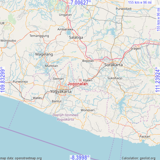
Jogonalan GPS coordinates[2]
7° 42' 12.996" South, 110° 32' 9.996" East
| Map corner | latitude | longitude |
|---|---|---|
| Upper-left | -7.00627°, | 109.83299° |
| Center: | -7.70361°, | 110.53611° |
| Lower-right: | -8.3998°, | 111.23924° |
| Map W x H: | 154.9×154.9 km | = 96.3×96.3mi |
| max Lat: | 5.88969° ⇑59.7% North |
| Jogonalan: | -7.70361° |
| min Lat: | ⇓40.3% South -10.934° |
| min Long | Jogonalan | max Long |
| 95.1345° | 110.53611° | 140.9419° |
| W 34.6%⇐ | ⇒65.4% E |
Elevation
Elevation of Jogonalan is 223 m = 732 ft, and this is 6.7 m = 22 ft below average elevation for this country.
| Max E: |
3185 m = 10449 ft | 34.9% |
| Avg. | 229.7 m = 754 ft | |
| Jogonalan | 223 m = 732 ft | |
Min E: |
-1 m = -3 ft | 65.1% |
See also: Indonesia elevation on elevation.city.
Geographical zone
Jogonalan is located in South Torrid zone (between Equator and Tropic of Capricorn). Distance of Equator is 856.6 km =532.3 mi to North.| Distance of | km | miles | from Jogonalan |
|---|---|---|---|
| Equator | 856.6 | 532.3 | to North |
| Tropic Capricorn | 1749.4 | 1087 | to South |
| Antarctic Circle | 6544.6 | 4066.6 | to South |
| South Pole | 9150.5 | 5685.9 | to South |


Nearby cities:
15 places around Jogonalan: (largest is in red/bold)
• Boyolali
20.1 km =12.5 mi,  19°
19°
• Candi Prambanan
6.9 km =4.3 mi,  221°
221°
• Ceper
16.1 km =10 mi,  78°
78°
• Delanggu
18.9 km =11.7 mi,  59°
59°
• Depok
13.2 km =8.2 mi,  240°
240°
• Gatak
22.4 km =13.9 mi, 55°
• Karanganom
11.5 km =7.1 mi, 58°
• Kebonarun
3 km =1.9 mi, 82°
• Klaten
7.7 km =4.8 mi,  91°
91°
• Melati
19 km =11.8 mi,  259°
259°
• Pugeran Maguwoharjo
14.5 km =9 mi, 240°
• Sleman
19.9 km =12.4 mi,  266°
266°
• Trucuk
13.6 km =8.5 mi,  96°
96°
• Wedi
6.5 km =4 mi,  132°
132°
• Yogyakarta
21.8 km =13.5 mi, 240°
Sources, notices
• [Note1] Compared only with cities in Indonesia existing in our database
• [Src1] Map data: © OpenStreetMap contributors (CC-BY-SA)
• [Src2] Other city data from geonames.org with taken over terms of usage.
• [Src3] Geographical zone / Annual Mean Temperature by Robert A. Rohde @ Wikipedia
