Sleman geodata
Sleman (Yogyakarta) is a seat of a second-order administrative division; located in Indonesia in Asia/Jakarta (GMT+7) time zone. With population of 56,215 people, there are 214 cities with bigger population in this country. Compared to other cities in Indonesia, 59.8% of cities are located further ↑North; 65.5% of cities are located further →East and 64.1% of cities have lower elevation than Sleman. Note1


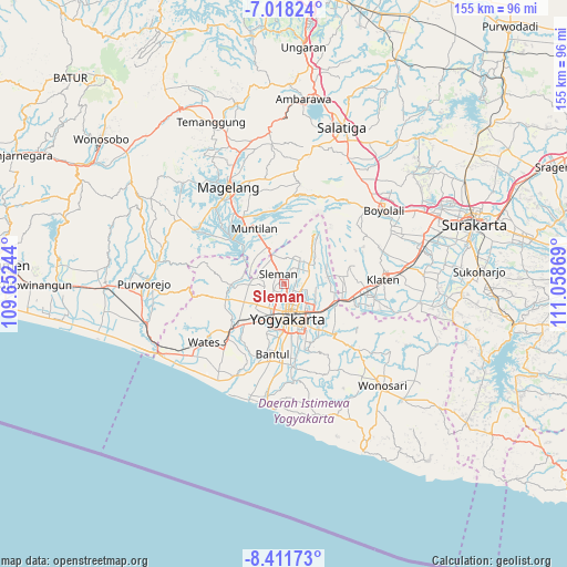
Sleman GPS coordinates[2]
7° 42' 56.016" South, 110° 21' 20.016" East
| Map corner | latitude | longitude |
|---|---|---|
| Upper-left | -7.01824°, | 109.65244° |
| Center: | -7.71556°, | 110.35556° |
| Lower-right: | -8.41173°, | 111.05869° |
| Map W x H: | 154.9×154.9 km | = 96.3×96.3mi |
| max Lat: | 5.88969° ⇑59.8% North |
| Sleman: | -7.71556° |
| min Lat: | ⇓40.2% South -10.934° |
| min Long | Sleman | max Long |
| 95.1345° | 110.35556° | 140.9419° |
| W 34.5%⇐ | ⇒65.5% E |
Elevation
Elevation of Sleman is 210 m = 689 ft, and this is 19.7 m = 65 ft below average elevation for this country.
| Max E: |
3185 m = 10449 ft | 35.9% |
| Avg. | 229.7 m = 754 ft | |
| Sleman | 210 m = 689 ft | |
Min E: |
-1 m = -3 ft | 64.1% |
See also: Sleman elevation on elevation.city.
Geographical zone
Sleman is located in South Torrid zone (between Equator and Tropic of Capricorn). Distance of Equator is 857.9 km =533.1 mi to North.| Distance of | km | miles | from Sleman |
|---|---|---|---|
| Equator | 857.9 | 533.1 | to North |
| Tropic Capricorn | 1748 | 1086.2 | to South |
| Antarctic Circle | 6543.3 | 4065.8 | to South |
| South Pole | 9149.2 | 5685 | to South |


Nearby cities:
15 places around Sleman: (largest is in red/bold)
• Bantul
19.4 km =12.1 mi,  188°
188°
• Candi Prambanan
15.7 km =9.8 mi,  104°
104°
• Depok
9.9 km =6.2 mi,  121°
121°
• Gamping Lor
9.5 km =5.9 mi,  199°
199°
• Godean
9.1 km =5.7 mi,  228°
228°
• Jogonalan
19.9 km =12.4 mi,  86°
86°
• Kasihan
12.7 km =7.9 mi, 193°
• Kebonarun
22.9 km =14.2 mi, 85°
• Melati
2.3 km =1.4 mi,  148°
148°
• Mungkid
20.3 km =12.6 mi,  312°
312°
• Muntilan
16.5 km =10.3 mi,  335°
335°
• Pandak
23 km =14.3 mi, 197°
• Pugeran Maguwoharjo
9.3 km =5.8 mi,  128°
128°
• Sewon
17.9 km =11.1 mi,  178°
178°
• Yogyakarta
9.6 km =6 mi,  173°
173°
Sources, notices
• [Note1] Compared only with cities in Indonesia existing in our database
• [Src1] Map data: © OpenStreetMap contributors (CC-BY-SA)
• [Src2] Other city data from geonames.org with taken over terms of usage.
• [Src3] Geographical zone / Annual Mean Temperature by Robert A. Rohde @ Wikipedia
