Bantul geodata
Bantul (Yogyakarta) is a seat of a second-order administrative division; located in Indonesia in Asia/Jakarta (GMT+7) time zone. With population of 58,653 people, there are 203 cities with bigger population in this country. Compared to other cities in Indonesia, 61.1% of cities are located further ↑North; 65.6% of cities are located further →East and 62.8% of cities have higher elevation than Bantul. Note1


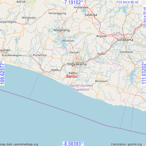
Bantul GPS coordinates[2]
7° 53' 17.016" South, 110° 19' 44.004" East
| Map corner | latitude | longitude |
|---|---|---|
| Upper-left | -7.19102°, | 109.62577° |
| Center: | -7.88806°, | 110.32889° |
| Lower-right: | -8.58393°, | 111.03202° |
| Map W x H: | 154.9×154.9 km | = 96.3×96.3mi |
| max Lat: | 5.88969° ⇑61.1% North |
| Bantul: | -7.88806° |
| min Lat: | ⇓38.9% South -10.934° |
| min Long | Bantul | max Long |
| 95.1345° | 110.32889° | 140.9419° |
| W 34.4%⇐ | ⇒65.6% E |
Elevation
Elevation of Bantul is 49 m = 161 ft, and this is 180.7 m = 593 ft below average elevation for this country.
| Max E: |
3185 m = 10449 ft | 62.8% |
| Avg. | 229.7 m = 754 ft | |
| Bantul | 49 m = 161 ft | |
Min E: |
-1 m = -3 ft | 37.2% |
See also: Bantul elevation on elevation.city.
Geographical zone
Bantul is located in South Torrid zone (between Equator and Tropic of Capricorn). Distance of Equator is 877.1 km =545 mi to North.| Distance of | km | miles | from Bantul |
|---|---|---|---|
| Equator | 877.1 | 545 | to North |
| Tropic Capricorn | 1728.8 | 1074.2 | to South |
| Antarctic Circle | 6524.1 | 4053.9 | to South |
| South Pole | 9130 | 5673.1 | to South |


Nearby cities:
15 places around Bantul: (largest is in red/bold)
• Bambanglipuro
8.5 km =5.3 mi,  216°
216°
• Candi Prambanan
23.8 km =14.8 mi,  49°
49°
• Depok
18 km =11.2 mi,  39°
39°
• Gamping Lor
10.3 km =6.4 mi,  358°
358°
• Godean
13.7 km =8.5 mi,  343°
343°
• Kasihan
6.8 km =4.2 mi,  0°
0°
• Melati
17.7 km =11 mi,  13°
13°
• Pandak
4.8 km =3 mi,  234°
234°
• Pugeran Maguwoharjo
16.8 km =10.4 mi, 37°
• Pundong
7.5 km =4.7 mi,  163°
163°
• Sewon
3.5 km =2.2 mi,  68°
68°
• Sleman
19.4 km =12.1 mi, 8°
• Srandakan
10.3 km =6.4 mi,  236°
236°
• Wates
19.2 km =11.9 mi,  280°
280°
• Yogyakarta
10.4 km =6.5 mi,  22°
22°
Sources, notices
• [Note1] Compared only with cities in Indonesia existing in our database
• [Src1] Map data: © OpenStreetMap contributors (CC-BY-SA)
• [Src2] Other city data from geonames.org with taken over terms of usage.
• [Src3] Geographical zone / Annual Mean Temperature by Robert A. Rohde @ Wikipedia
