Rambangaru geodata
Rambangaru (East Nusa Tenggara) is a seat of a third-order administrative division; located in Indonesia in Asia/Makassar (GMT+8) time zone. In our database, there are 407 cities with bigger population. Compared to other cities in Indonesia, 92.9% of cities are located further ↑North; 82.9% of cities are located further ←West and 85.2% of cities have higher elevation than Rambangaru. Note1


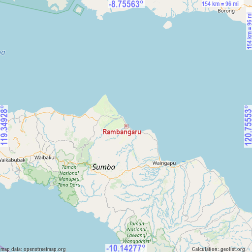
Rambangaru GPS coordinates[2]
9° 26' 59.64" South, 120° 3' 8.64" East
| Map corner | latitude | longitude |
|---|---|---|
| Upper-left | -8.75563°, | 119.34928° |
| Center: | -9.4499°, | 120.0524° |
| Lower-right: | -10.14277°, | 120.75553° |
| Map W x H: | 154.2×154.2 km | = 95.8×95.8mi |
| max Lat: | 5.88969° ⇑92.9% North |
| Rambangaru: | -9.4499° |
| min Lat: | ⇓7.1% South -10.934° |
| min Long | Rambangaru | max Long |
| 95.1345° | 120.0524° | 140.9419° |
| W 82.9%⇐ | ⇒17.1% E |
Elevation
Elevation of Rambangaru is 14 m = 46 ft, and this is 215.7 m = 708 ft below average elevation for this country.
| Max E: |
3185 m = 10449 ft | 85.2% |
| Avg. | 229.7 m = 754 ft | |
| Rambangaru | 14 m = 46 ft | |
Min E: |
-1 m = -3 ft | 14.8% |
See also: Indonesia elevation on elevation.city.
Geographical zone
Rambangaru is located in South Torrid zone (between Equator and Tropic of Capricorn). Distance of Equator is 1050.7 km =652.9 mi to North.| Distance of | km | miles | from Rambangaru |
|---|---|---|---|
| Equator | 1050.7 | 652.9 | to North |
| Tropic Capricorn | 1555.2 | 966.4 | to South |
| Antarctic Circle | 6350.4 | 3946 | to South |
| South Pole | 8956.3 | 5565.2 | to South |


Nearby cities:
15 places around Rambangaru: (largest is in red/bold)
• Bidihunggar
6.3 km =3.9 mi,  331°
331°
• Kamalaputi
32 km =19.9 mi,  133°
133°
• Kambatatamakawu
17.7 km =11 mi,  280°
280°
• Kapunduk
0.5 km =0.3 mi, 275°
• Karara
30.4 km =18.9 mi,  136°
136°
• Karipidita
29.4 km =18.3 mi,  184°
184°
• Kowingir
1 km =0.6 mi,  197°
197°
• Landa
24.5 km =15.2 mi, 130°
• Lokuuy
29.1 km =18.1 mi,  243°
243°
• Napu
15.1 km =9.4 mi,  293°
293°
• Ngarangiakambera
25.1 km =15.6 mi,  191°
191°
• Retijawa
6.9 km =4.3 mi, 128°
• Tambulatana
17.4 km =10.8 mi,  113°
113°
• Umburarameha
31.8 km =19.8 mi, 138°
• Wairinding
26.3 km =16.3 mi,  161°
161°
Sources, notices
• [Note1] Compared only with cities in Indonesia existing in our database
• [Src1] Map data: © OpenStreetMap contributors (CC-BY-SA)
• [Src2] Other city data from geonames.org with taken over terms of usage.
• [Src3] Geographical zone / Annual Mean Temperature by Robert A. Rohde @ Wikipedia
