Negeriagung geodata
Negeriagung (South Sumatra) is a seat of a third-order administrative division; located in Indonesia in Asia/Jakarta (GMT+7) time zone. In our database, there are 407 cities with bigger population. Compared to other cities in Indonesia, 89.8% of cities are located further ↓South; 95.3% of cities are located further →East and 59.3% of cities have higher elevation than Negeriagung. Note1


Negeriagung GPS coordinates[2]
3° 46' 2.28" South, 103° 39' 5.76" East
| Map corner | latitude | longitude |
|---|---|---|
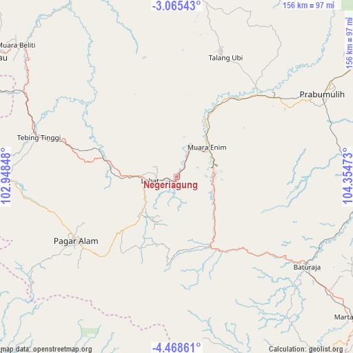
| Upper-left | -3.06543°, | 102.94848° |
| Center: | -3.7673°, | 103.6516° |
| Lower-right: | -4.46861°, | 104.35473° |
| Map W x H: | 156×156 km | = 96.9×96.9mi |
| max Lat: | 5.88969° ⇑10.2% North |
| Negeriagung: | -3.7673° |
| min Lat: | ⇓89.8% South -10.934° |
| min Long | Negeriagung | max Long |
| 95.1345° | 103.6516° | 140.9419° |
| W 4.7%⇐ | ⇒95.3% E |
Elevation
Elevation of Negeriagung is 62 m = 203 ft, and this is 167.7 m = 550 ft below average elevation for this country.
| Max E: |
3185 m = 10449 ft | 59.3% |
| Avg. | 229.7 m = 754 ft | |
| Negeriagung | 62 m = 203 ft | |
Min E: |
-1 m = -3 ft | 40.7% |
See also: Indonesia elevation on elevation.city.
Geographical zone
Negeriagung is located in South Torrid zone (between Equator and Tropic of Capricorn). Distance of Equator is 418.9 km =260.3 mi to North.| Distance of | km | miles | from Negeriagung |
|---|---|---|---|
| Equator | 418.9 | 260.3 | to North |
| Tropic Capricorn | 2187 | 1358.9 | to South |
| Antarctic Circle | 6982.3 | 4338.6 | to South |
| South Pole | 9588.2 | 5957.8 | to South |


Nearby cities:
15 places around Negeriagung: (largest is in red/bold)
• Baturaja
69.9 km =43.4 mi,  125°
125°
• Bunga Mas
32.3 km =20.1 mi,  283°
283°
• Gunungmegang Dalam
42.8 km =26.6 mi,  34°
34°
• Kotaagung
41.4 km =25.7 mi,  216°
216°
• Lahat
12.2 km =7.6 mi,  260°
260°
• Muara Enim
18.7 km =11.6 mi,  45°
45°
• Muaradua
39.2 km =24.4 mi,  186°
186°
• Muarapinang
67 km =41.6 mi, 262°
• Pagar Alam
53.3 km =33.1 mi,  237°
237°
• Pengandonan
40.5 km =25.2 mi,  141°
141°
• Pulaupinang
20 km =12.4 mi,  226°
226°
• Suban Jeriji
34.7 km =21.6 mi,  86°
86°
• Talang Ubi
59 km =36.7 mi,  19°
19°
• Tanjungagung
25.4 km =15.8 mi, 138°
• Tebing Tinggi
66.9 km =41.6 mi,  287°
287°
Sources, notices
• [Note1] Compared only with cities in Indonesia existing in our database
• [Src1] Map data: © OpenStreetMap contributors (CC-BY-SA)
• [Src2] Other city data from geonames.org with taken over terms of usage.
• [Src3] Geographical zone / Annual Mean Temperature by Robert A. Rohde @ Wikipedia
