Kramat geodata
Kramat (East Java) is a seat of a fourth-order administrative division; located in Indonesia in Asia/Jakarta (GMT+7) time zone. In our database, there are 407 cities with bigger population. Compared to other cities in Indonesia, 59.7% of cities are located further ↑North; 62% of cities are located further ←West and 99.7% of cities have higher elevation than Kramat. Note1


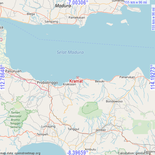
Kramat GPS coordinates[2]
7° 42' 1.44" South, 113° 29' 22.56" East
| Map corner | latitude | longitude |
|---|---|---|
| Upper-left | -7.00306°, | 112.78648° |
| Center: | -7.7004°, | 113.4896° |
| Lower-right: | -8.39659°, | 114.19273° |
| Map W x H: | 154.9×155 km | = 96.3×96.3mi |
| max Lat: | 5.88969° ⇑59.7% North |
| Kramat: | -7.7004° |
| min Lat: | ⇓40.3% South -10.934° |
| min Long | Kramat | max Long |
| 95.1345° | 113.4896° | 140.9419° |
| W 62%⇐ | ⇒38% E |
Elevation
Elevation of Kramat is 2 m = 7 ft, and this is 227.7 m = 747 ft below average elevation for this country.
| Max E: |
3185 m = 10449 ft | 99.7% |
| Avg. | 229.7 m = 754 ft | |
| Kramat | 2 m = 7 ft | |
Min E: |
-1 m = -3 ft | 0.3% |
See also: Indonesia elevation on elevation.city.
Geographical zone
Kramat is located in South Torrid zone (between Equator and Tropic of Capricorn). Distance of Equator is 856.2 km =532 mi to North.| Distance of | km | miles | from Kramat |
|---|---|---|---|
| Equator | 856.2 | 532 | to North |
| Tropic Capricorn | 1749.7 | 1087.2 | to South |
| Antarctic Circle | 6545 | 4066.9 | to South |
| South Pole | 9150.9 | 5686.1 | to South |


Nearby cities:
15 places around Kramat: (largest is in red/bold)
• Besuki
23.2 km =14.4 mi,  99°
99°
• Bringinanom
6.1 km =3.8 mi,  219°
219°
• Jabung Wetan
4.6 km =2.9 mi,  183°
183°
• Jabungsisir
4.1 km =2.5 mi,  212°
212°
• Jambesari
37 km =23 mi,  198°
198°
• Kalibuntu
8.9 km =5.5 mi,  243°
243°
• Krajan Alastengah
5.5 km =3.4 mi,  173°
173°
• Krajan Jabungcandi
3.9 km =2.4 mi,  193°
193°
• Krajan Kebonagung
6.9 km =4.3 mi, 220°
• Kraksaan
12.1 km =7.5 mi, 237°
• Parseh
6.3 km =3.9 mi, 210°
• Probolinggo
30.7 km =19.1 mi,  258°
258°
• Randumerak
3.2 km =2 mi, 197°
• Sidodadi
4.3 km =2.7 mi, 172°
• Tanjung Kidul
2.5 km =1.6 mi,  157°
157°
Sources, notices
• [Note1] Compared only with cities in Indonesia existing in our database
• [Src1] Map data: © OpenStreetMap contributors (CC-BY-SA)
• [Src2] Other city data from geonames.org with taken over terms of usage.
• [Src3] Geographical zone / Annual Mean Temperature by Robert A. Rohde @ Wikipedia
