Alung geodata
Alung (South Kalimantan) is a seat of a third-order administrative division; located in Indonesia in Asia/Makassar (GMT+8) time zone. In our database, there are 407 cities with bigger population. Compared to other cities in Indonesia, 92.2% of cities are located further ↓South; 74.6% of cities are located further ←West and 80.9% of cities have higher elevation than Alung. Note1


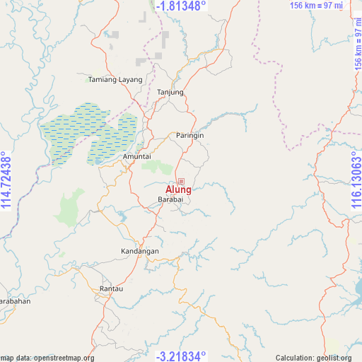
Alung GPS coordinates[2]
2° 30' 57.96" South, 115° 25' 39" East
| Map corner | latitude | longitude |
|---|---|---|
| Upper-left | -1.81348°, | 114.72438° |
| Center: | -2.5161°, | 115.4275° |
| Lower-right: | -3.21834°, | 116.13063° |
| Map W x H: | 156.2×156.2 km | = 97.1×97.1mi |
| max Lat: | 5.88969° ⇑7.8% North |
| Alung: | -2.5161° |
| min Lat: | ⇓92.2% South -10.934° |
| min Long | Alung | max Long |
| 95.1345° | 115.4275° | 140.9419° |
| W 74.6%⇐ | ⇒25.4% E |
Elevation
Elevation of Alung is 18 m = 59 ft, and this is 211.7 m = 695 ft below average elevation for this country.
| Max E: |
3185 m = 10449 ft | 80.9% |
| Avg. | 229.7 m = 754 ft | |
| Alung | 18 m = 59 ft | |
Min E: |
-1 m = -3 ft | 19.1% |
See also: Indonesia elevation on elevation.city.
Geographical zone
Alung is located in South Torrid zone (between Equator and Tropic of Capricorn). Distance of Equator is 279.8 km =173.9 mi to North.| Distance of | km | miles | from Alung |
|---|---|---|---|
| Equator | 279.8 | 173.9 | to North |
| Tropic Capricorn | 2326.2 | 1445.4 | to South |
| Antarctic Circle | 7121.4 | 4425 | to South |
| South Pole | 9727.3 | 6044.3 | to South |


Nearby cities:
15 places around Alung: (largest is in red/bold)
• Alabio
21.5 km =13.4 mi,  288°
288°
• Barabai
8.9 km =5.5 mi,  213°
213°
• Barikin
21.5 km =13.4 mi, 212°
• Batumandi
10.6 km =6.6 mi,  8°
8°
• Birayang
3.6 km =2.2 mi,  121°
121°
• Haruyan
21.3 km =13.2 mi,  203°
203°
• Kasarangan
19 km =11.8 mi,  229°
229°
• Lampihung
18.7 km =11.6 mi,  36°
36°
• Pagat
12.1 km =7.5 mi,  176°
176°
• Pantaihambawang
18 km =11.2 mi,  216°
216°
• Paringin
20.7 km =12.9 mi, 14°
• Pendawanbaru
20.7 km =12.9 mi,  265°
265°
• Putatbasiun
15.5 km =9.6 mi,  46°
46°
• Sungaiturak
18.6 km =11.6 mi,  345°
345°
• Telagaselaba
19.4 km =12.1 mi,  319°
319°
Sources, notices
• [Note1] Compared only with cities in Indonesia existing in our database
• [Src1] Map data: © OpenStreetMap contributors (CC-BY-SA)
• [Src2] Other city data from geonames.org with taken over terms of usage.
• [Src3] Geographical zone / Annual Mean Temperature by Robert A. Rohde @ Wikipedia
