Barabai geodata
Barabai (South Kalimantan) is a populated place; located in Indonesia in Asia/Makassar (GMT+8) time zone. With population of 60,192 people, there are 198 cities with bigger population in this country. Compared to other cities in Indonesia, 92% of cities are located further ↓South; 74.2% of cities are located further ←West and 83% of cities have higher elevation than Barabai. Note1


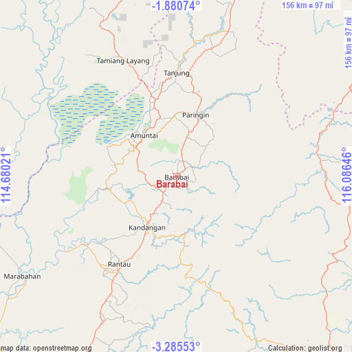
Barabai GPS coordinates[2]
2° 34' 59.988" South, 115° 22' 59.988" East
| Map corner | latitude | longitude |
|---|---|---|
| Upper-left | -1.88074°, | 114.68021° |
| Center: | -2.58333°, | 115.38333° |
| Lower-right: | -3.28553°, | 116.08646° |
| Map W x H: | 156.2×156.2 km | = 97.1×97.1mi |
| max Lat: | 5.88969° ⇑8% North |
| Barabai: | -2.58333° |
| min Lat: | ⇓92% South -10.934° |
| min Long | Barabai | max Long |
| 95.1345° | 115.38333° | 140.9419° |
| W 74.2%⇐ | ⇒25.8% E |
Elevation
Elevation of Barabai is 16 m = 52 ft, and this is 213.7 m = 701 ft below average elevation for this country.
| Max E: |
3185 m = 10449 ft | 83% |
| Avg. | 229.7 m = 754 ft | |
| Barabai | 16 m = 52 ft | |
Min E: |
-1 m = -3 ft | 17% |
See also: Barabai elevation on elevation.city.
Geographical zone
Barabai is located in South Torrid zone (between Equator and Tropic of Capricorn). Distance of Equator is 287.2 km =178.5 mi to North.| Distance of | km | miles | from Barabai |
|---|---|---|---|
| Equator | 287.2 | 178.5 | to North |
| Tropic Capricorn | 2318.7 | 1440.8 | to South |
| Antarctic Circle | 7113.9 | 4420.4 | to South |
| South Pole | 9719.8 | 6039.6 | to South |


Nearby cities:
15 places around Barabai: (largest is in red/bold)
• Alabio
21.1 km =13.1 mi,  312°
312°
• Alung
8.9 km =5.5 mi,  33°
33°
• Amuntai
23.7 km =14.7 mi,  321°
321°
• Angkimang
18.7 km =11.6 mi,  205°
205°
• Barikin
12.5 km =7.8 mi, 211°
• Batumandi
19.1 km =11.9 mi,  19°
19°
• Birayang
9.7 km =6 mi,  54°
54°
• Haruyan
12.6 km =7.8 mi,  197°
197°
• Kasarangan
10.7 km =6.6 mi,  243°
243°
• Loklaga
14.4 km =8.9 mi,  184°
184°
• Pagat
7.2 km =4.5 mi,  129°
129°
• Pantaihambawang
9.1 km =5.7 mi,  219°
219°
• Pasingkan
22.3 km =13.9 mi, 239°
• Pendawanbaru
16.8 km =10.4 mi,  290°
290°
• Telagaselaba
23.6 km =14.7 mi,  341°
341°
Sources, notices
• [Note1] Compared only with cities in Indonesia existing in our database
• [Src1] Map data: © OpenStreetMap contributors (CC-BY-SA)
• [Src2] Other city data from geonames.org with taken over terms of usage.
• [Src3] Geographical zone / Annual Mean Temperature by Robert A. Rohde @ Wikipedia
