Botawa geodata
Botawa (Papua) is a seat of a second-order administrative division; located in Indonesia in Asia/Jayapura (GMT+9) time zone. In our database, there are 407 cities with bigger population. Compared to other cities in Indonesia, 92.6% of cities are located further ↓South; 99.4% of cities are located further ←West and 93.7% of cities have higher elevation than Botawa. Note1


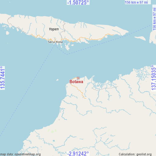
Botawa GPS coordinates[2]
2° 12' 36" South, 136° 26' 49.992" East
| Map corner | latitude | longitude |
|---|---|---|
| Upper-left | -1.50725°, | 135.7441° |
| Center: | -2.21°, | 136.44722° |
| Lower-right: | -2.91242°, | 137.15035° |
| Map W x H: | 156.2×156.2 km | = 97.1×97.1mi |
| max Lat: | 5.88969° ⇑7.4% North |
| Botawa: | -2.21° |
| min Lat: | ⇓92.6% South -10.934° |
| min Long | Botawa | max Long |
| 95.1345° | 136.44722° | 140.9419° |
| W 99.4%⇐ | ⇒0.59999999999999% E |
Elevation
Elevation of Botawa is 8 m = 26 ft, and this is 221.7 m = 727 ft below average elevation for this country.
| Max E: |
3185 m = 10449 ft | 93.7% |
| Avg. | 229.7 m = 754 ft | |
| Botawa | 8 m = 26 ft | |
Min E: |
-1 m = -3 ft | 6.3% |
See also: Indonesia elevation on elevation.city.
Geographical zone
Botawa is located in South Torrid zone (between Equator and Tropic of Capricorn). Distance of Equator is 245.7 km =152.7 mi to North.| Distance of | km | miles | from Botawa |
|---|---|---|---|
| Equator | 245.7 | 152.7 | to North |
| Tropic Capricorn | 2360.2 | 1466.6 | to South |
| Antarctic Circle | 7155.4 | 4446.2 | to South |
| South Pole | 9761.3 | 6065.4 | to South |


Nearby cities:
15 places around Botawa: (largest is in red/bold)
• Ansus
88.8 km =55.2 mi,  307°
307°
• Barapas
61.6 km =38.3 mi,  88°
88°
• Biak
121.9 km =75.7 mi,  340°
340°
• Bilogai
169.5 km =105.3 mi,  171°
171°
• Bosnik
119.6 km =74.3 mi,  348°
348°
• Homeyo
161.6 km =100.4 mi,  179°
179°
• Insrom
127.1 km =79 mi, 338°
• Korem
152.5 km =94.8 mi, 342°
• Korido
173.8 km =108 mi,  328°
328°
• Nabire
165.5 km =102.8 mi,  219°
219°
• Serui
43.1 km =26.8 mi, 328°
• Sumberbaba
55.5 km =34.5 mi,  38°
38°
• Trimuris
156.9 km =97.5 mi,  79°
79°
• Wardo
144.3 km =89.7 mi, 332°
• Waren
13.9 km =8.6 mi,  244°
244°
Sources, notices
• [Note1] Compared only with cities in Indonesia existing in our database
• [Src1] Map data: © OpenStreetMap contributors (CC-BY-SA)
• [Src2] Other city data from geonames.org with taken over terms of usage.
• [Src3] Geographical zone / Annual Mean Temperature by Robert A. Rohde @ Wikipedia
