Nabire geodata
Nabire (Papua) is a seat of a second-order administrative division; located in Indonesia in Asia/Jayapura (GMT+9) time zone. With population of 43,898 people, there are 256 cities with bigger population in this country. Compared to other cities in Indonesia, 90.6% of cities are located further ↓South; 99.2% of cities are located further ←West and 93.7% of cities have higher elevation than Nabire. Note1


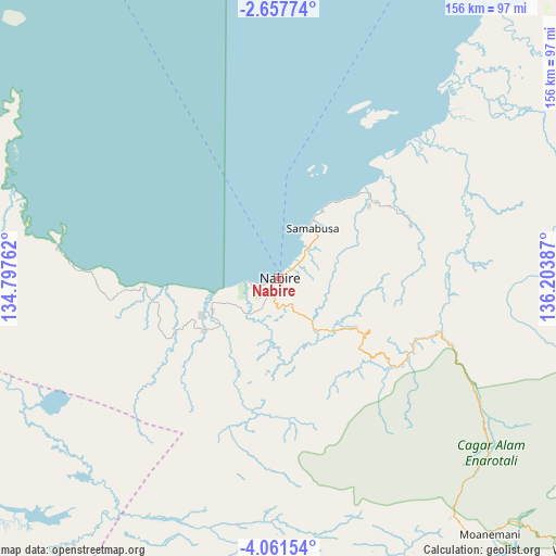
Nabire GPS coordinates[2]
3° 21' 35.604" South, 135° 30' 2.664" East
| Map corner | latitude | longitude |
|---|---|---|
| Upper-left | -2.65774°, | 134.79762° |
| Center: | -3.35989°, | 135.50074° |
| Lower-right: | -4.06154°, | 136.20387° |
| Map W x H: | 156.1×156.1 km | = 97×97mi |
| max Lat: | 5.88969° ⇑9.4% North |
| Nabire: | -3.35989° |
| min Lat: | ⇓90.6% South -10.934° |
| min Long | Nabire | max Long |
| 95.1345° | 135.50074° | 140.9419° |
| W 99.2%⇐ | ⇒0.8% E |
Elevation
Elevation of Nabire is 8 m = 26 ft, and this is 221.7 m = 727 ft below average elevation for this country.
| Max E: |
3185 m = 10449 ft | 93.7% |
| Avg. | 229.7 m = 754 ft | |
| Nabire | 8 m = 26 ft | |
Min E: |
-1 m = -3 ft | 6.3% |
See also: Nabire elevation on elevation.city.
Geographical zone
Nabire is located in South Torrid zone (between Equator and Tropic of Capricorn). Distance of Equator is 373.6 km =232.1 mi to North.| Distance of | km | miles | from Nabire |
|---|---|---|---|
| Equator | 373.6 | 232.1 | to North |
| Tropic Capricorn | 2232.3 | 1387.1 | to South |
| Antarctic Circle | 7027.6 | 4366.7 | to South |
| South Pole | 9633.5 | 5986 | to South |


Nearby cities:
15 places around Nabire: (largest is in red/bold)
• Bilogai
135.6 km =84.3 mi,  107°
107°
• Bomomani
86 km =53.4 mi,  155°
155°
• Enarotali
116 km =72.1 mi,  123°
123°
• Homeyo
112.6 km =70 mi, 107°
• Kigamani
83 km =51.6 mi,  143°
143°
• Kiruru
87.3 km =54.2 mi,  222°
222°
• Kumopa
123.1 km =76.5 mi, 114°
• Kwantisore
66.8 km =41.5 mi,  279°
279°
• Moanemani
95.7 km =59.5 mi,  134°
134°
• Obano
102.2 km =63.5 mi, 128°
• Rasiei
123.6 km =76.8 mi,  299°
299°
• Tigi
108.5 km =67.4 mi, 128°
• Topo
20.5 km =12.7 mi,  168°
168°
• Waghete
114.4 km =71.1 mi, 131°
• Wasior
137.9 km =85.7 mi,  305°
305°
Sources, notices
• [Note1] Compared only with cities in Indonesia existing in our database
• [Src1] Map data: © OpenStreetMap contributors (CC-BY-SA)
• [Src2] Other city data from geonames.org with taken over terms of usage.
• [Src3] Geographical zone / Annual Mean Temperature by Robert A. Rohde @ Wikipedia
