Ujung Gading geodata
Ujung Gading (West Sumatra) is a seat of a third-order administrative division; located in Indonesia in Asia/Jakarta (GMT+7) time zone. In our database, there are 407 cities with bigger population. Compared to other cities in Indonesia, 95.3% of cities are located further ↓South; 97.6% of cities are located further →East and 70.2% of cities have higher elevation than Ujung Gading. Note1


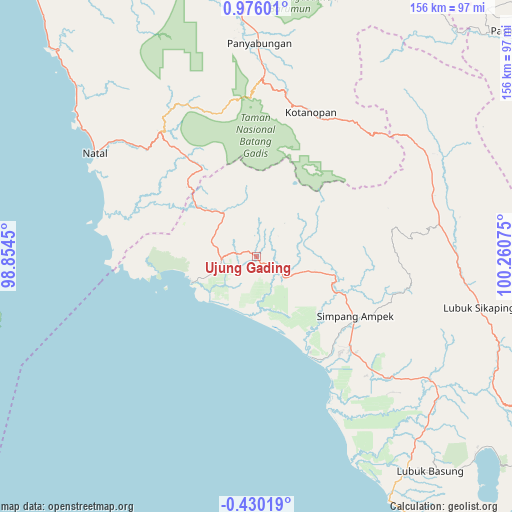
Ujung Gading GPS coordinates[2]
0° 16' 22.548" North, 99° 33' 27.432" East
| Map corner | latitude | longitude |
|---|---|---|
| Upper-left | 0.97601°, | 98.8545° |
| Center: | 0.27293°, | 99.55762° |
| Lower-right: | -0.43019°, | 100.26075° |
| Map W x H: | 156.4×156.4 km | = 97.2×97.2mi |
| max Lat: | 5.88969° ⇑4.7% North |
| Ujung Gading: | 0.27293° |
| min Lat: | ⇓95.3% South -10.934° |
| min Long | Ujung Gading | max Long |
| 95.1345° | 99.55762° | 140.9419° |
| W 2.4%⇐ | ⇒97.6% E |
Elevation
Elevation of Ujung Gading is 32 m = 105 ft, and this is 197.7 m = 649 ft below average elevation for this country.
| Max E: |
3185 m = 10449 ft | 70.2% |
| Avg. | 229.7 m = 754 ft | |
| Ujung Gading | 32 m = 105 ft | |
Min E: |
-1 m = -3 ft | 29.8% |
See also: Indonesia elevation on elevation.city.
Geographical zone
Ujung Gading is located in North Torrid zone (between Equator and Tropic of Cancer). Distance of Equator is 30.3 km =18.8 mi to South.| Distance of | km | miles | from Ujung Gading |
|---|---|---|---|
| North Pole | 9976.7 | 6199.2 | to North |
| Arctic Circle | 7370.8 | 4580 | to North |
| Tropic Cancer | 2575.6 | 1600.4 | to North |
| Equator | 30.3 | 18.8 | to South |


Nearby cities:
15 places around Ujung Gading: (largest is in red/bold)
• Air Bangis
21.3 km =13.2 mi,  248°
248°
• Bonjol
81.2 km =50.5 mi,  113°
113°
• Kotanopan
47 km =29.2 mi,  20°
20°
• Lubuk Basung
87.2 km =54.2 mi,  139°
139°
• Lubuk Sikaping
69.1 km =42.9 mi,  101°
101°
• Muara Sipongi
60.4 km =37.5 mi,  56°
56°
• Muara Soma
51.1 km =31.8 mi,  334°
334°
• Natal
59.3 km =36.8 mi,  302°
302°
• Panti
56.2 km =34.9 mi,  79°
79°
• Panyambungan
65.8 km =40.9 mi,  359°
359°
• Siabu
82.9 km =51.5 mi, 355°
• Sibuhuan
88.9 km =55.2 mi,  12°
12°
• Simpang Empat
35.4 km =22 mi,  123°
123°
• Talu
47.3 km =29.4 mi, 95°
• Tiku
84.7 km =52.6 mi,  151°
151°
Sources, notices
• [Note1] Compared only with cities in Indonesia existing in our database
• [Src1] Map data: © OpenStreetMap contributors (CC-BY-SA)
• [Src2] Other city data from geonames.org with taken over terms of usage.
• [Src3] Geographical zone / Annual Mean Temperature by Robert A. Rohde @ Wikipedia
