Sibuhuan geodata
Sibuhuan (North Sumatra) is a seat of a second-order administrative division; located in Indonesia in Asia/Jakarta (GMT+7) time zone. In our database, there are 407 cities with bigger population. Compared to other cities in Indonesia, 96.3% of cities are located further ↓South; 97.5% of cities are located further →East and 58.9% of cities have lower elevation than Sibuhuan. Note1


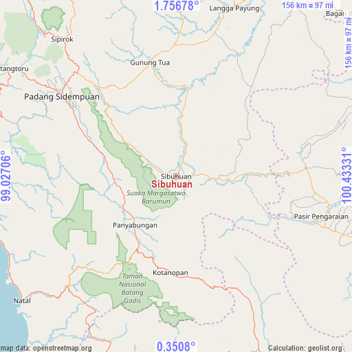
Sibuhuan GPS coordinates[2]
1° 3' 13.932" North, 99° 43' 48.648" East
| Map corner | latitude | longitude |
|---|---|---|
| Upper-left | 1.75678°, | 99.02706° |
| Center: | 1.05387°, | 99.73018° |
| Lower-right: | 0.3508°, | 100.43331° |
| Map W x H: | 156.3×156.3 km | = 97.1×97.1mi |
| max Lat: | 5.88969° ⇑3.7% North |
| Sibuhuan: | 1.05387° |
| min Lat: | ⇓96.3% South -10.934° |
| min Long | Sibuhuan | max Long |
| 95.1345° | 99.73018° | 140.9419° |
| W 2.5%⇐ | ⇒97.5% E |
Elevation
Elevation of Sibuhuan is 153 m = 502 ft, and this is 76.7 m = 252 ft below average elevation for this country.
| Max E: |
3185 m = 10449 ft | 41.1% |
| Avg. | 229.7 m = 754 ft | |
| Sibuhuan | 153 m = 502 ft | |
Min E: |
-1 m = -3 ft | 58.9% |
See also: Indonesia elevation on elevation.city.
Geographical zone
Sibuhuan is located in North Torrid zone (between Equator and Tropic of Cancer). Distance of Equator is 117.2 km =72.8 mi to South.| Distance of | km | miles | from Sibuhuan |
|---|---|---|---|
| North Pole | 9889.9 | 6145.3 | to North |
| Arctic Circle | 7284 | 4526.1 | to North |
| Tropic Cancer | 2488.7 | 1546.4 | to North |
| Equator | 117.2 | 72.8 | to South |


Nearby cities:
15 places around Sibuhuan: (largest is in red/bold)
• Binanga
39.9 km =24.8 mi,  7°
7°
• Dalududalu
57.3 km =35.6 mi,  86°
86°
• Gunung Tua
52.3 km =32.5 mi,  347°
347°
• Kotanopan
43 km =26.7 mi,  183°
183°
• Langgapayung
79.2 km =49.2 mi,  19°
19°
• Muara Sipongi
62.4 km =38.8 mi,  149°
149°
• Muara Soma
57.7 km =35.9 mi,  225°
225°
• Padangsidempuan
62.5 km =38.8 mi,  305°
305°
• Panyambungan
28.8 km =17.9 mi,  223°
223°
• Pasarujungbatu
24.3 km =15.1 mi, 94°
• Pasir Pengaraian
66.3 km =41.2 mi,  108°
108°
• Pintupadang
47.6 km =29.6 mi,  295°
295°
• Siabu
26.5 km =16.5 mi,  260°
260°
• Sipirok
79.3 km =49.3 mi,  320°
320°
• Ujungbatu
22.8 km =14.2 mi, 93°
Sources, notices
• [Note1] Compared only with cities in Indonesia existing in our database
• [Src1] Map data: © OpenStreetMap contributors (CC-BY-SA)
• [Src2] Other city data from geonames.org with taken over terms of usage.
• [Src3] Geographical zone / Annual Mean Temperature by Robert A. Rohde @ Wikipedia
